Reorganisation of the Surveying System in the Eastern Part of Germany
after Reunification - Examples and Outlook
by Klaus Kummer
Key words: real estate cadastre, state survey, organization,
training, further training.
Abstract
1. Introduction
According to the socio-political situation in the
GDR the official surveying was in a subordinate position. As a matter
of fact the government was not interested in title registration of
owners put down in the real estate cadastre and in the property
register. The fundamental geodetic survey together with the official
geodetic reference systems on one hand and the geotopography with the
national topographic map series on the other hand were of no social
and public significance because of their degree of secrecy. Therefore
the quality assurance of official abstract of title was neglected in
favour of other priorities. Another result was that the utilisation of
national topographic maps was not controlled consequently enough
because of their lack of intensive public and private
practice-orientated use. While engineering surveys and military
surveying could develop well, real estate cadastre and state survey
had to be totally reorganised and rebuilt after reunification. The
enormous requirements of qualified personnel were not available for
this task.
2. Fields of Reorganization
Beside the complete renewal of real estate cadastre
in terms of quality and its simultaneous changeover to automatic
running, the official topography and cartography were to set up a new
foundation, to open for general usage and to extend to a digitally
kept geotopographic base information system. In the fundamental
geodetic survey new reference systems based on modern
satellite-assisted positioning and navigation procedures had to be
created. Main focus is also on training and further training because
of a board reform of organisation in this field. The complete
rebuilding process of official surveying will be presented with the
help of assurance components of several kind, e.g. components for
professional, reorganizational and staff quality assurance in the
federal state of Saxony-Anhalt.
3. Components for Professional Quality Assurance
Apart from the fact that the original of land tax
register had to be changed into automated keeping, the cadastrial map
with 90.000 map sheets at the scale 1:1000 had to be renewed
completely. After a cadastre-photogrammetic area-wide photo flight
over the region, the new cadastral map with approximately 3 million
plots and a totally updated holding of buildings will be digitally
available in the year 2002. Within a short time the cadastral measures
and computations will be scanned by analogue field sheets and
organised by a document administration system. The cadastral surveying
is to be done resistant to modification in surveying co-ordinate
systems. These systems work independently from any reference systems.
Presently there are 40.000 fixed points of horizontal control network
that are going to be replaced by modern satellite-assisted procedures.
The state Saxony-Anhalt has been covered area-wide by 18 satellite
reference units (distance 30 to 50 km) which give their data
permanently to the receiving stations. Concerning the national
topographic map series the changeover to digital keeping has been
completed at the base scale range of 1:10.000. Today main focus is on
developing an integrated geotopographic basic information system.
4. Components for Re-organizational Quality Assurance
The official surveying in Saxony-Anhalt is
structured as a slim two-stage administration with altogether 3.000
employees. There we have only 13 large efficient working local
authorities. Methods like on-site competence and self-control had to
be optimised to make the principle of quality assurance more
effective. Because of a short-decision-process the services of
official surveying is fast and user friendly. To carry out cadastral
surveying, 65 land surveyors received an additional qualification and
passed a specific examination. After that they were able to get a
registration as authorised Registered Land Surveyors with a quality
obligation relating to professional law.
5. Components for Staff Quality Assurance
In order to remedy the deficiency of qualified
personnel - never existing before to such an extent - the official
surveying started a state-run training campaign. Within the last few
years after reunification more than 1.700 land surveyors and surveying
technicians received a special training in the state Saxony-Anhalt (a
territory of 25 to 30% of the Czech Republic). To meet the
requirements of quality assurance the personnel of official surveying
is further trained in special courses at state’s universities. These
courses are offered additionally to general available training
opportunities in the scope of training programs - accompanying
profession like „Berufliche Weiterbildung BWB" (Continuing
Professional Development, CPD) of „Deutscher Verein für
Vermessungswesen DVW". This exclusive program contains 10
different events per year, each lasting for several days. The
achievement quote per year of further training (further training event
/ complete personnel) of the state’s official surveying
administration amounts more than 80% by now.
6. Conclusion and Outlook
Today the official surveying in the Eastern states
of Germany has reached West German standards. And shows a high level
of quality assurance. Main focus of professional development referring
to official surveying of every federal state in Germany is to merge
all registers of real estate cadastre with official geotopography in
order to have an integrated geographical geobase information system of
the state. Redundant databases and previous covered discrepancies will
be abolished systematically by the complete adjustment of registers.
This is another module for the quality assurance system of German
official surveying.
Professor Dr. Klaus Kummer
Ministerium des Innern des Landes Sachsen-Anhalt
Halberstädter Straße 2
D-39112 Magdeburg
GERMANY
Tel. + 49 391 567 5418
Fax + 49 391 567 5435
E-mail: VuKV@min.mi.lsa-net.de
Web site: http://www.mi.sachsen-anhalt.de
Reorganisation of the Surveying System in the Eastern Part of Germany
after Reunification - Examples and Outlook
ABSTRACT
After reunification the official surveying system in the
new federal states of Germany had to be reorganized and rebuilt completely.
Taking Saxony-Anhalt as an example for this process it will demonstrate how
reconstruction in terms of professional, reorganization and staff components
could introduce and assure a high quality of real estate cadastre and state
surveying.
1. Introduction
According to the social-political situation in the GDR
the official surveying was in a subordinate position. As a matter of fact
the government was not interested in title registration of owners put down
in the real estate cadastre and in the property register. The fundamental
geodetic survey together with the official geodetic reference systems on one
hand and the geotopography with the national topographic map series on the
other hand were of no social and public significance because of their degree
of secrecy. Therefore the quality assurance of official abstract of title
was neglected in favour of other priorities. Another result was that the
utilization of national topographic maps was not controlled consequently
enough because of their lack of intensive public and private
practice-orientated use. While engineering surveys and military surveying
could develop well, real estate cadastre and state survey had to be totally
reorganized and rebuilt after reunification. The enormous requirements of
qualified personnel were not available for this task.
2. FIELDS OF REORGANIZATION
Official surveying includes the following fields of
reorganization:
Real estate cadastre with
- real estate register,
- real estate map,
- cadastral surveying and
- cadastral measures and computations as well as
State survey with
- basic geodetic surveys / geodetic reference systems and
- authoritative topographic maps / topographical survey.
The real estate cadastre had to be completely
renewed not only with regard to quality but in a similar manner it had to be
changed into automated keeping. The register and records of basic minor
control point were partly on a prewar level. Most parcels could not be found
in plans indicating proposed sectional title boundaries and were not even
registered in maps. Beside the regular tasks in the state Saxony-Anhalt with
approximately 3 million parcels and about 2,5 million buildings there was a
huge work of renewal due to be dealt with [Kummer 1996a and 1996b].
After reunification - first time for decades - the authoritative
topographic maps could be opened for general usage. They had to be
adjusted to new reference systems and adapted according to the West German
mapping system. In addition to that the authoritative topographic maps had
to be changed over to digital keeping. In the area of basic geodetic
surveys the high point control network and the gravitational point
control network were conceived anew in whole Germany. For control network
there was made a conclusion about the new reference system "ETRS"
on the basis of satellite-assisted surveys.
For the whole area of official surveying there had to be
introduced a complete new professional law and all regulations needed to be
adopted [Kummer, Möllering 1998]. Based on the new law a modern
organization set-up had to be introduced as well [Kummer 1995a]. Only 30% of
3000 necessary qualified staff members (engineers and technicians) were at
the state’s disposal. Most of them were not prepared enough for these
tasks. Because of this reason the official surveying started a training
and further training campaign - never existed before to such an extend -
and it still goes on until today.
The complete reorganization of state surveying included
all professional and personnel fields and this way it resembles a great deal
with an integrated quality assurance package.
3. COMPONENTS FOR PROFESSIONAL QUALITY ASSURANCE
In Saxony-Anhalt the keeping of descriptive data in real
estate cadastre changed completely into digital „ALB-technique"
already in 1993. Beside the cadastre data there is information about more
professional data concerning each affected parcel. Today the land tax
register is a relevant area-wide basic information system referring to
parcels on a digital base [Kummer 1996b].
3.2 Cadastral map
The cadastral map as the illustrative element of real
estate cadastre was close to decline in 1990. A number of about 14.000 old
certified extracts from cadastral map series with nonstandard and far to
small map scales could not be used for the new tasks. Therefore a state-wide
major campaign for an extensive map renewal was initiated. This campaign
will be completed in the year 2002 and will include the following elements:
- changeover from old certified extracts from cadastral map series to
transparent films including a complete recording on microfilm
(consolidation of product);
- area-wide photo flight over the region to a scale 1:3.500 and
production of rectified aerial pictures to a scale 1:1.000 (information,
purpose of planning);
- registration of the whole amount of new surveys since 1991 into 90.000
certified extracts from cadastral map series - that were empty before
that - to a scale 1:1.000, analysis of aerial pictures and transfer of
all buildings that were measured out in aerial pictures into new
certified extracts from cadastral map series, at the same time
changeover of new extracts from cadastral map series into digital
keeping;
- scanning of parcel limits out of old map series, enlarge into scale
1:1.000 and fit into new digitally kept certified extracts from
cadastral map series.
As a result there will be 90.000 cadastral maps -
digitally kept in "ALK-technique" - at a standardized scale in the
year 2002 in Saxony-Anhalt. They show the relevant, complete inventory of
buildings in the region and will be worked upon furthermore. Within a period
of only 10 years a map renewal 1:1.000 with the help of cadastral
photogrammetry will be successfully completed, which is unique for an
area-land. With conventional, terrestrial methods this renewal would have
taken more than 100 years and were impossible to finance. The renewal of
cadastre is described in detail in literature ([Kummer 1994a], [Grams,
Loddeke-Thies 1998], [Kummer 1998a]).
3.3 Cadastral surveying and cadastral measure and computations
In Saxony-Anhalt cadastral surveying is carried out not
by an official location reference system, but by a local map referred
systems of coordinates that is seen in relation to station level. This way
cadastral measures and computations with more than 20 million object
point-coordinates exit independently from changes of geodetic based systems.
Such a change is due to be dealt with soon when ETRS-System 89 will be
introduced [Kummer 1995b]. Because of being resistant to reference system
changes a genuine safety mechanism of basic data is reached this way. This
mechanism is in detail described in literature ([Kummer 1994b, 1996b,
1998a], [Beul 1995]).
In addition to "survey coordinates" with an
exactness of 0,02 m "map coordinates" for the cadastral map are
kept as well. They are calculated from survey coordinates through
transformation about identical control points and comply with the
regulations of exactness 0,2 m because of cadastral map scales (1:1.000).
That is the reason why changes of the relation system are not able to
detract from map precision and can be controlled in spite of quantity. In
Saxony-Anhalt there are kept 2 data files for cadastral measure and
computations as emerges from the following figure 1.
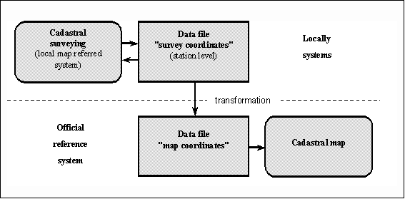
Figure 1: Principle of keeping cadastral
measure and computations
Aside from digital keeping of data files for cadastral
measure and computations the results of cadastral surveying in their
geometric context are kept up to now in analog and graphical cadastral field
sheets. Soon documents will be scanned and automatically administrated in a
document management system.
3.4 Horizontal control network
Presently 40.000 control points of horizontal control
network are getting determined anew by satellite-assisted procedures. The
state Saxony-Anhalt has been covered area-wide by 18 permanent satellite
reference units (distance 30 to 50 km). With the help of this units
cadastral surveying and more detailed surveying, positioning and navigation
can be carried out precisely and very economically. The permanent satellite
reference units function as representatives of the official location
reference system ([Beul 1995], [Patzschke, Leipholz 1996], [Kummer 1998a]).
The area-wide construction of permanent units is shown in the following
figure 2.
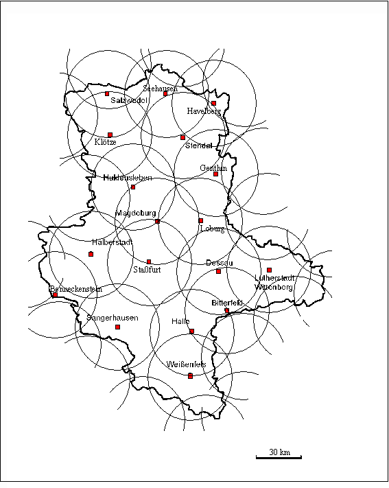
Figure 2: Permanent satellite units in Saxony-Anhalt
3.5 Authoritative topographic maps
Concerning authoritative topographic maps the state
Saxony-Anhalt has area-wide analog map systems on file to the following
scales: 1:10.000, 1:25.000, 1:50.000, 1:100.000, 1:200.000, 1:500.000 and
1:1 million. The changeover to digital keeping as authoritative topographic
cartographic information system (Amtliches Topographisch-Kartographisches
Informationssystem "ATKIS") has been completed area-wide in the
state to the topographic basic scale 1:10.000. In addition to that a digital
plot model to a scale of 1:50.000 will be constructed soon. The Federal
Bureau of Cartography and Geodesy (Bundesamt für Kartographie und Geodäsie
"BKG") brings out digital plot models to a scale of 1:250.000 and
1:1 million. The changeover to digital keeping is of profound significance
in terms of quality assurance measures. The conception for new digitally
kept geotopographic information system plans to replace the conventional
analog map system. From digital land models all interim scales can be
derived as presentations.
4. COMPONENTS FOR REORGANIZATIONAL QUALITY ASSURANCE
First there was in Saxony-Anhalt a 3-step administration
structure of professional administration:
- 39 offices of local authority (real estate cadastre),
- 4 offices of intermediate authority (regulatory authority and land
survey office) and
- 2 departments in the Ministry of the Interior.
These 45 administration units have been reformed
completely and reorganized extensively. Today professional administration in
the state Saxony-Anhalt is organized as a slim two-stage administration
structure with only 12 cadastral authorities, 1 land survey authority and 1
regulatory authority inside the Ministry of the Interior. This way the
former 45 administration units are put together to 14 highly efficient
units. Hereby methods like on-site competence and self-control are optimized
in a way that the principle of quality assurance became even more effective.
Because of a short-decision process the service is fast and user friendly.
The administration structure is shown in the following figure 3.
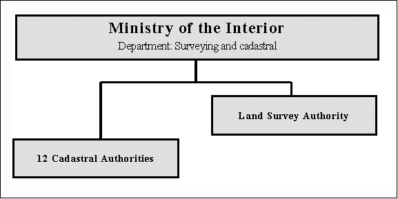
Figure 3: Administration structure of
professional administration in the state Saxony-Anhalt
A cadastral authority employs on average 100 salaried
staff members and it is responsible for an average area of 1.700 square km,
for 230.000 inhabitants and 250.000 parcels. The land survey office is in
charge of the entire state of Saxony-Anhalt ([Kummer 1999a, Dieckmann
1997]).
Together with the professional administration the
Registered Land surveyors of the state belong to official surveying. They
are authorized to do local cadastral surveying. In Saxony-Anhalt it is
prescribed that cadastral surveying is carried out to 20% by cadastral
authorities and to 80% by Registered Land surveyors [Kummer 1998b].
Altogether 65 Land surveyors received an additional qualification and passed
a specific examination. After that they were able to get a registration as
authorized Registered Land surveyors with a quality obligation relating to
professional law.
4.2 Internal organization of authorities
The multi-step hierarchy structure of authorities was cut
back for the benefit of only 1 organization level-departments. The
departments are the only organizational units. For example the Land Survey
authority is with 400 employees structured as follows [Kummer 1999a]:
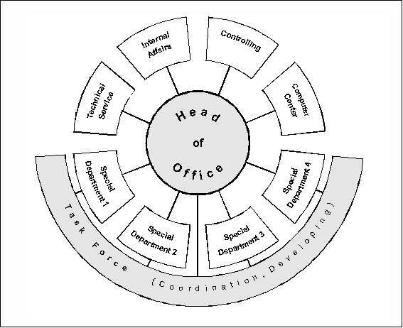
Figure 4: Internal organization of Land
Survey authorities in Saxony-Anhalt
With support of this kind of slim hierarchy the
authorities are guided by economically orientated principles of management.
Apart from this they are obliged to fulfill only government duties [Kummer
1999b].
5. COMPONENTS FOR STAFF QUALITY ASSURANCE
In order to remedy the deficiency of qualified personnel
- a deficiency that never existed before to such an extent - the official
surveying started a state-run training campaign after reunification. Within
the last few years after reunification more than 1.700 land surveyors and
surveying technicians received a special training in the state Saxony-Anhalt
(a territory 25 to 30% of the Czech Republic). It was very helpful that the
course of study "surveying" could be established at
"Professional College Anhalt" in Dessau [Götz, Schallehn 1996].
The technical training is carried out by professional administration.
5.2 Professional further education
In order to meet the requirements of quality assurance
the personnel of official surveying is further trained systematically in
special courses at state’s colleges. These courses are offered
additionally to general available training opportunities in the scope of
training programs - accompanying professional occupation like „Berufliche
Weiterbildung, BWB" (Continuing Professional Development, CPD) of
"Deutscher Verein für Vermessungswesen, DVW" (The German
Association of surveying). This exclusive program contains 10 different
events per year, each goes on for several days. The achievement quote per
year of further training (further training event ./. complete personnel) of
the state’s official surveying administration amounts today already more
than 80% [Schultze 2000]. Further training for graduates who finished
university is carried out at the University of Applied Sciences in Dresden [Augath
1999], engineers are educated at the "Professional College Anhalt"
[Keller 1997] and survey technicians are qualified within departments of
professional administration [Schultze 2000]. Each participant receives a
confirmation (certificate) for the attendance at a training course. The
certificate follows a standardized DVW-pattern and the participant collects
her/his confirmation into a personal BWB-documentation book. Additionally
staff members attend more courses that are listed in the DVW further
training catalog. The certain structure of BWB system of "Deutscher
Verein für Vermessungswesen" is detailed described in literature [Kölbel
et al 1996], [Mehlhorn et al 1998].
6. CONCLUSION AND OUTLOOK
Today the official surveying in the Eastern states of
Germany has reached West German standards and it offers a high level of
quality assurance. Main focus of professional development referring to
official surveying of every federal state in Germany is to merge all
registers of real estate cadastre with official geotopography in order to
have an integrated, area-related, automated geobase information system of
the country [Beul 1998], [Grote 1999]. The conception as a whole is shown in
the following figure 5.
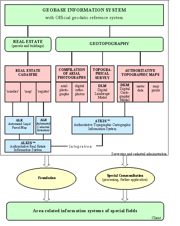
Figure 5: Area-related information system
Registers, maps and records are adjusted systematically
and completely as a result of establishing an entire system. Redundant
databases and previous covered discrepancies will be revealed and abolished.
This is another module for the quality assurance system of German official
surveying.
references
Augath, W. 1999: Universitäre
berufliche Weiterbildung an der TU Dresden, Zeitschrift für das
Öffentliche Vermessungswesen des Landes Sachsen-Anhalt 1999, S. 83-90,
Ministerium des Innern des Landes Sachsen-Anhalt, Magdeburg 1999.
Beul, D. 1995: Einsatz
satellitengestützter Verfahren für Aufgaben der präzisen Vermessung im
Land Sachsen-Anhalt, Zeitschrift für das Öffentliche Vermessungswesen des
Landes Sachsen-Anhalt 1995, S. 91-104, Ministerium des Innern des Landes
Sachsen-Anhalt, Magdeburg 1995.
Beul, D. 1998: Das
Geobasisinformationssystem LSA der VuKV - Raumbezugsgrundlage,
Organisationsgrundlage und Fachinformation für andere Informationssysteme
-, Zeitschrift für das Öffentliche Vermessungswesen des Landes
Sachsen-Anhalt 1998, S. 85-95, Ministerium des Innern des Landes
Sachsen-Anhalt, Magdeburg 1998.
Dieckmann, C. 1997: Die
Verwaltungsreform in der Vermessungs- und Katasterverwaltung, Zeitschrift
für das Öffentliche Vermessungswesen des Landes Sachsen-Anhalt 1997, S.
110-125, Ministerium des Innern des Landes Sachsen-Anhalt, Magdeburg 1997.
Götz, B., Schallehn, W. 1996: Ergänzungsstudiengang
Vermessungswesen an der Fachhochschule Anhalt, Zeitschrift für das
Öffentliche Vermessungswesen des Landes Sachsen-Anhalt 1996, S. 156-161,
Ministerium des Innern des Landes Sachsen-Anhalt, Magdeburg 1996.
Grams P., Loddeke-Thies, M. 1998: Digital
geführte Liegenschaftskarte in der VuKV in Sachsen-Anhalt, Zeitschrift für
das Öffentliche Vermessungswesen des Landes Sachsen-Anhalt 1998, S. 3-36,
Ministerium des Innern des Landes Sachsen-Anhalt, Magdeburg 1998.
Grote, T. 1999: Integriertes
Geobasisinformationssystem - das Projekt ALKIS/ATKIS, Zeitschrift für das
Öffentliche Vermessungswesen des Landes Sachsen-Anhalt 1999, S. 37-56,
Ministerium des Innern des Landes Sachsen-Anhalt, Magdeburg 1999.
Keller, D. 1997:
Fort- und Weiterbildung für Vermessungsingenieure - erste Erfahrungen in
Sachsen-Anhalt, Zeitschrift für das Öffentliche Vermessungswesen des
Landes Sachsen-Anhalt 1997, S. 104-109, Ministerium des Innern des Landes
Sachsen-Anhalt, Magdeburg 1997.
Kölbel, B. et al 1996: Management
im Vermessungswesen, Zeitschrift für Vermessungswesen 121, S. 476-485,
Wittwer Verlag, Stuttgart 1996.
Kummer, K. 1994a: Die
Erneuerung der Liegenschaftskarte im Land Sachsen-Anhalt, Zeitschrift für
Vermessungswesen 119, S. 71-84, Wittwer Verlag, Stuttgart 1994a.
Kummer, K. 1994b: Liegenschaftsvermessungen
- warum mit Gauß-Krüger-Koordinaten? - Das Land Sachsen-Anhalt geht einen
neuen Weg -, Schriftenreihe des DVW Band 12, S. 6-17, Wittwer Verlag,
Stuttgart 1994b.
Kummer, K. 1995a: Das
Öffentliche Vermessungswesen im Land Sachsen-Anhalt, Zeitschrift für das
Öffentliche Vermessungswesen des Landes Sachsen-Anhalt 1995, S. 5-20,
Ministerium des Innern des Landes Sachsen-Anhalt, Magdeburg 1995a.
Zur Einführung und Anwendung des ETRS im Land Sachsen-Anhalt, Zeitschrift
für das Öffentliche Vermessungswesen des Landes Sachsen-Anhalt 1995, S.
80-90, Ministerium des Innern des Landes Sachsen-Anhalt, Magdeburg 1995b.
Kummer, K. 1996a:
Management und Aufgabenerledigung in der Vermessungs- und Katasterverwaltung,
Zeitschrift für das Öffentliche Vermessungswesen des Landes Sachsen-Anhalt
1996, S. 93-102, Ministerium des Innern des Landes Sachsen-Anhalt, Magdeburg
1996a.
Kummer, K. 1996b:
Liegenschaftskataster im Wandel - Konzeption und Erneuerung im Land
Sachsen-Anhalt -, Festschrift Hans Pelzer, Wissenschaftliche Arbeiten der
Fachrichtung Vermessungswesen der Universität Hannover Nr. 209, S. 151-
170, Fachrichtung Vermessungswesen, Hannover 1996b.
Kummer, K. 1998a:
Lösungsstrategie für ein bezahlbares amtliches Vermessungswesen,
Vermessungswesen und Raumordnung 1998, S. 172-189, Dümmler Verlag, Bonn
1998a.
Kummer, K. 1998b:
Gemeinsam mit der Verwaltung für den Bürger, Forum 1998, S. 325-335, BDVI,
Köln 1998b.
Kummer, K. 1999a:
Von der hierarchischen Aufbaustruktur zur dynamischen Projektorganisation -
Neues Steuerungsmodell für die Landesvermessung in Sachsen-Anhalt,
Zeitschrift für Vermessung 124, S. 33-42, Wittwer Verlag, Stuttgart 1999a.
Kummer, K. 1999b:
Modernisierungsprinzipien für die Vermessungs- und Katasterverwaltung -
Erwerbswirtschaftsunternehmen oder Agentur-Verwaltung? -, Zeitschrift für
das Öffentliche Vermessungswesen des Landes Sachsen-Anhalt 1999, S. 6-18,
Ministerium des Innern des Landes Sachsen-Anhalt, Magdeburg 1999b.
Kummer, K., Möllering, H. 1998:
Vermessungs- und Katasterrecht Sachsen-Anhalt, Kommentar, Kommunal- und
Schulverlag, Wiesbaden 1998.
Mehlhorn, R. et al 1998:
Modellstruktur Berufliche Weiterbildung - Das DVW-Projekt BWB-, Zeitschrift
für Vermessungswesen 124, S. 193-201, Wittwer Verlag, Stuttgart 1998.
Patzschke, S., Leipholz, T. 1996:
GPS-Referenzstationen im Land Sachsen-Anhalt, Zeitschrift für das
Öffentliche Vermessungswesen des Landes Sachsen-Anhalt 1996, S. 140-155,
Ministerium des Innern des Landes Sachsen-Anhalt, Magdeburg 1996.
Schultze, K. 2000:
Zur Bedeutung der Aus- und Fortbildung im Personalmanagement der technischen
Fachverwaltung, Vermessungswesen und Raumordnung 2000, Heft 2, Luchterhand
Verlag, Neuwied 2000.
Geodesy Studies at the University of Applied Sciences in Hannover,
diploma degree "Dipl-Ing." and Ph.D. degree "Dr.-Ing.",
Second state examination;
Leader of the Official Surveying Sector in Saxony-Anhalt;
Teaching at the University of Applied Sciences in Dresden (chair of the Geodetic
Institute), appointment as a professor;
More than 40 publications in all fields of the Official Surveying; work
centres presently: real estate cadastre, management, administration
reform, efficiency, law;
Prizewinner "Gerhard-Eichhorn-Preis" of The German Association
of Surveying (DVW);
Co-autor of the book "Kommentar Vermessungs- und Katasterrecht";
Co-editor of the specialist journal " Vermessungswesen und
Raumordnung - VR";
Member of the "Kuratorium des Oberprüfungsamtes für die höheren
technischen Verwaltungsbeamten" in Frankfurt/Main and examiner in the
division "Vermessungs- und Liegenschaftswesen" (Surveying and
Landmanagement);
Representative of the federal state of Saxony-Anhalt in the Plenum of
the Working Committee of the Surveying Authorities of the States of the
Federal Republic of Germany (AdV);
Member of the Study Group 1 (Professional Standards and Practice) of The
German Association of Surveying (DVW).
Professor Dr. Klaus Kummer
Ministerium des Innern des Landes Sachsen-Anhalt
E-mail: VuKV@min.mi.lsa-net.de
Web site: http://www.mi.sachsen-anhalt.de
27 March 2000
|