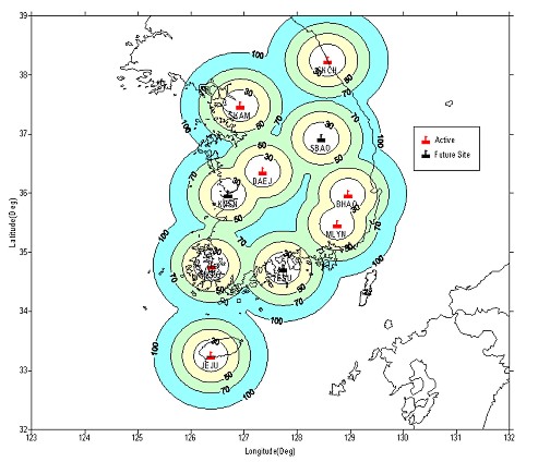
THE DEVELOPMENT OF DGPS SERVICE SYSTEM USING FM DARC (EYEDIO) IN KOREAJonguk PARK, Jeongho JOH, Hyungchul LIM, Pilho PARK and Sangwoon Lee, KoreaKey words: GPS, DGPS, FM DARC, GPS NETWORK. AbstractThe major milestone in the beginning of domestic GPS business in Korea was achieved when Korea Astronomy Observatory (KAO) introduced three precise surveying GPS receivers from Trimble in October 1989. And an epoch-making turning point in GPS research was on 1st, January 1994, when KAO GPS station played an active role of International GPS Service (IGS). During the last decade, GPS-related research activities of KAO have been expanded to the fields of Positional Astronomy, Geodesy, Surveying, Seismology, Meteorology, Geomatics, and other GPS applications like as GIS, ITS. One of the major activities of KAO GPS Research Group for domestic GPS society is to operate a nationwide GPS network, which is consist of seven Continuously Operating Reference Station (CORS) systems including a IGS site DAEJ. KAO provide the observation data of reference stations for the post-processing applications through internet and the DGPS correction data via FM DAta Radio Channel (DARC) for the real-time applications. The Munhwa Broadcasting Corp. (MBC), one of the major broadcasting companies in Korea, started to broadcast the DGPS data using FM DARC from the 2nd, December 1999. A self-defined, compressed algorithm for DGPS data transmission format is adopted to provide the maximun 11 satellites in three packets (63 bytes) considering the data transfer capability and the performance of DARC. The EYEDIO, a nickname of FM DARC system operated by MBC, broadcasts now the DGPS data provided by KAO's 7 stations. The received data are converted to the RTCM SC-104 message types at a dedicated FM receiver unit, and can be transferred to the user with communication port. The delay time of broadcasting DGPS data is less than one second and positioning accuracy is decimeter level when using the high precision GPS receiver. At the end of last year, MBC expanded the coverage area to the 70% of population, including six major cities in Korea. This service will cover the nationwide area in the second half of 2001. The precise descriptions, such as the configurations and functions of FM DARC/DGPS service system in Korea, will be addressed in this paper. It then describes the preliminary results and analysis in the static application of GPS. INTRODUCTIONIn the beginning of the 90's, Korea Astronomy Observatory (KAO) started the GPS-related researches with the development project for GPS engine software. At that time, KAO introduced a high-precision GPS processing software from Bern University, Switzerland and installed a permanent GPS monument for the pilot program of International GPS Service (IGS) and Western-pacific Integrated Network for GPS (WING). In 1996, the GPS Research Group of KAO had finished the 3-years project for the determination of coordinate transformation parameters between the WGS84 and the Korean datum. The accuracy of coordinates transformation could be achieved within 20 cm for all components when using the results from the above projects and the geoid model developed by Pusan National University, Korea. In the second half of the last decade, GPS-related research activities of KAO have been expanded to the fields of Positional Astronomy, Geodesy, Surveying, Seismology, Meteorology and Geomatics through participating in many projects supported by government and private companies. One of the major activities of KAO GPS Research Group for domestic GPS society is to operate a nationwide GPS network, which is consist of seven Continuously Operating Reference Station (CORS) systems including a IGS site DAEJ. KAO provides the observation data of reference stations for the post-processing applications via Internet. For the real-time DGPS users group, KAO broadcasts the correction data of reference using FM DAta Radio Channel (DARC) operated by the Munhwa Broadcasting Corp. (MBC), one of the major broadcasting companies in Korea. MBC started to broadcast the DGPS data with other information, such as traffic information, using FM DARC from the 2nd, December 1999. A self-defined, compressed algorithm for DGPS data transmission format is adopted to provide the maximun 11 satellites in three packets (63 bytes) considering the data transfer capability and the performance of DARC. The delay time of broadcasting DGPS data is less than one second and positioning accuracy is decimeter level when using the high precision GPS receiver. In this paper, the precise descriptions of KAO GPS network system, FM DARC system, and the configurations and functions of FM DARC/DGPS service system in Korea, will be addressed. It then describes the preliminary results and analysis in the static application of GPS. THE GPS NETWORK OF KOREA ASTRONOMY OBSERVATORYFrom early 1999, the GPS Research Group of KAO started to establish a nationwide GPS network for the multiple purpose of GPS-related research fields. As of August 2000, the KAO has 7 CORS systems, scheduled to have 10 CORSs, and a GPS Network Center (KAOGNC) in Taejon, Korea (Figure 1). Precise coordinates of the reference station were computed using Bernese GPS Software Version 4.2 (Lim et. al., 2000). As shown in figure 1, the GPS network sites of KAO are well distributed to cover the whole country and the inter-spacing range from 100 km to 200km.
Figure 1. DGPS coverage map for the KAO GPS network
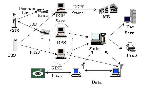
Figure 2. The system configurations of KAO GPS network Each of the CORS has the same design except an IGS site DAEJ. The unmanned reference station is equipped with a dual-frequency GPS receiver, a choke-ring antenna, two communication units and a control system for the electric power and temperature in the special shelter within GPS tower. Especially the reference station in Taejon, which is one of IGS sites, consists of a 5m concrete monument with choke-ring antenna and the observation room in the KAO. A high-precision, dual-frequency GPS receiver and two Cesium clocks are operating in this temperature-controlled room. In addition, an Uninterrupted Power Supply (UPS) is also installed for an unpredicted power failure. The KAO uses Trimble Navigation Ltd. 12 channel, dual-frequency 4000SSITM geodetic surveyor as a reference receiver. The reference station receives and processes signals from visible GPS satellites and compute corrections for Differential GPS (DGPS). Each of CORS sends the observation raw-data and the DGPS correction data formatted in Radio Technical Commission for Maritime Services (RTCM) type to the KAO GPS Network Center (KAOGNC) in real-time. The communications between the reference station and the KAOGNC is performed via a dedicated digital line with 9.6Kbps. Moreover, an ISDN line is connected to the each CORS for the redundancy. The GPS Network Center of KAO (figure 2) is equipped with the modem pool for data-link with reference stations, the computer systems for data handling, a router and a network terminal unit. The communications between center and broadcasting station are linked to the TCP/IP protocol within a Frame-Relay network. The softwares running at the center have the following functions:
KAO archive and backup the GPS observation data of 7 CORSs from August, 1999. It is available to use these reference data for post-processing freely. From that time, the DGPS server in the network center generates the special format of RTCM message for FM DARC and broadcasts it to the real-time DGPS users via the nationwide FM network of MBC. FM DARC SYSTEMFM broadcast uses the high-quality frequency band (88-108MHz) which has excellent propagation characteristics because of high transmitting power and optimal transmission post. Due to these characteristics, broadcast transmission has wide area coverage and can be well fitted in mobile reception. In addition to these characteristics, FM has some advantages in providing the digital data as below:
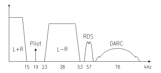
FM stereo broadcast is allowed to use 100 KHz baseband to transmit stereophonic signals, but it uses only 53 KHz bandwidths. Therefore, the redundant 53-100 KHz band can be used for digital data or other stereophonic services. Some methods for the utilization of this redundancy are Radio Data System (RDS) with a low transmission rate of 1187.5 bps, and Data Radio Channel (DARC) with a high transmission rate of 16 Kbps. Figure 3 shows the baseband spectrum of FM stereo broadcast including RDS and DARC signals.
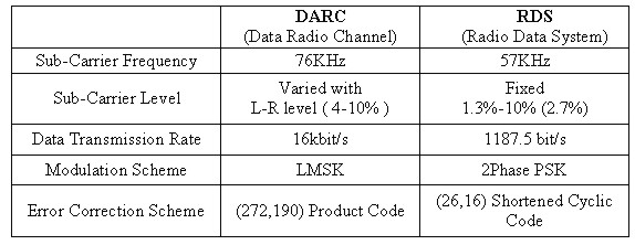
Figure 3. Base band Spectrum of FM Stereo Table 1 presents a comparison of DARC and RDS. As shown in Table 1, the data transmission in DARC is accomplished by adding digital data using the Level-controlled Minimum Shift Keying (LMSK) modulation scheme on stereophonic signal in FM baseband. DARC is in commercial service in Japan, U.S. and European countries and free of charge in Korea (Lee et. al., 1998). Table 1. A comparison between DARC and RDS
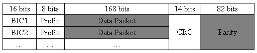
DGPS SERVICE SYSTEM USING FM DARC IN KOREADifferential GPS (DGPS) is a technique that significantly improves both the accuracy and the integrity of Global Positioning System. In general, the reference station receives and process signals from GPS satellites, estimates the slowly varying error components of each satellites range measurement from known position. This approach using the scalar corrections to the code measurement is so called Local Area Differential GPS (LADGPS), and typical ranges for a LADGPS station are up to 150 km (Parkinson and Spilker, 1996). The RTCM Special Committee No. 104 (RTCM SC-104) recommended the standards to transfer DGPS data and the link methods (RTCM, 1998). This standard provides the 64 message related with differential GPS and address the communication link methods such as radio beacon and FM sub-carrier. The cost-effective candidate to transfer DGPS data of reference stations is to use FM DARC system described above. Figure 4 shows a configuration of DARC data packet (layer 2 & 3) accordance with 7-layer reference model described in ITU-R Recommendation 807 (ITU, 1992).
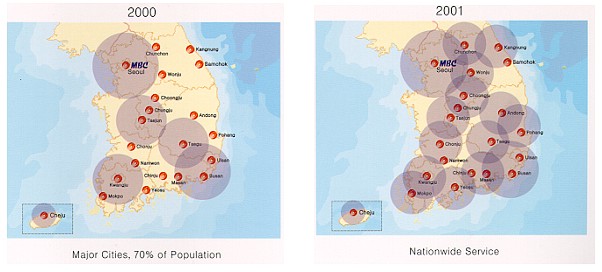
Figure 4. A configuration of DARC data packet (layer 2 & 3) As shown in figure 4, FM DARC has the 21 bytes in each packet. KAO adopted the self-defined, compressed algorithm as DGPS data transmission format to provide the 11 satellites maximum in three packets (61 data bytes & 2 CRC bytes) for considering the data transfer capability and the performance of DARC. This algorithm eliminates parity data that is consists of 6 bits and a large framing overhead at the broadcasting unit. It is possible to encode the received data as RTCM SC-104 message format at a receiver unit. These procedures are capable because RTCM SC-104 formats was patterned after the GPS data format like as GPS word size, word format and parity algorithm (ARINC Research Corp., 1991). In the case of RTCM SC-104 format for 11 GPS satellites, it has to broadcast totally 105 bytes including the 21 parity bytes. The received data are converted to the RTCM SC-104 message types at a dedicated FM receiver unit, and can be transferred to the users with its communication port The Munhwa Broadcasting Corp. (MBC), one of the major broadcasting companies in Korea, started to broadcast the DGPS data with other information using FM DARC on the 2nd, December 1999. The EYEDIO, a nickname of FM DARC system operated by MBC, broadcasts now the DGPS data provided by KAO's 7 stations. At the end of last year, MBC expanded the coverage area to the 70% of population, including six major cities in Korea. This service will cover the nationwide area in the second half of 2001 (Figure 5). When this system apply to the DGPS applications, the delay time of broadcasting DGPS data is less than one second. The accuracy of positioning is to achieve to the decimeter level when using the high precision GPS receiver.
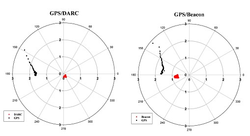
Figure 5. The Coverage area of EYEDIO. FIELD TESTDuring February 2001, we carried out several field tests to check the accuracy and the reliability of FM DARC/DGPS service. Trimble 4000SSi receivers observed GPS signals with DGPS data received from FM DARC/DGPS unit. The high precision coordinates of selected posts were computed using GPSurveyTM (Trimble, 1996) with the code and carrier-phase data of reference stations. In order to compare the accuracy of DGPS positioning between DGPS link methods, we adopted a radio beacon DGPS service that is operated by the Ministry of Maritime Affairs and Fisheris (MOMAF), Korea. Each observation continued 5 minutes at 1-second sampling rate. The observed mask angle was set to 10°. Table 2 and figure 6 show the one of testing results in DGPS static positioning. Table 2. Summary of statistics for test results.
Figure 6 (a) & (b). A test results of DGPS static positioning with FM DARC and radio beacon. On the behalf of turning off Selective Availability (SA) from May 2000, the accuracy of stand-alone GPS positioning can reach the meter level with high precision GPS receiver. However, DGPS positioning dramatically improve the positioning accuracy both FM DARC and radio beacon services as shown in table 2 and figure 6. The results show the decimeter level accuracy of 2D and 3D distance from precise positions when using FM DARC/DGPS service. Moreover, the 2drms values are less than 1 meter in both cases. The latency of DGPS data from FM DARC is in a second and the receiveing rate of data is 100% perfectly. Considering the long baseline distance of DGPS radio beacon site of MOMAF, it seems that the same positiong accuracy could be provided by radio beacon DGPS system. The results show that DGPS technique using FM DARC has a capability of providing the decimeter level positiong in static GPS application fields. CONCLUSION & FUTURE WORKKAO and MBC co-worked in development of the DGPS service system using FM DARC in Korea. This system provides the DGPS data within one second to users and the decimeter accuracy in the case of using a high-precision GPS receiver. In spite of minor disadvantages of FM DARC system, the accuracy and reliability of this service are remarkable to use high precision DGPS positioning in many GPS application areas. The Korea Astronomy Observatory is now developing the broadcasting system for Real-Time Kinematic (RTK) data via FM DARC. At the end of 2001, when the RTK service system using FM DARC is in fully operational, KAO will support concurrent high-precision GPS positioning in both DGPS and RTK applications in Korea ACKNOWLEDGEMENTSThe first author would like to express his sincere thanks to the members of Bway Co. Ltd. for their efforts to the development of dedicated FM DARC/KDGPS receiver and the field tests. REFERENCESARINC Research Corporation, 1991, NAVSTAR GPS SPACE SEGMENT/ NAVIGATION USER INTERFACE, ICD-GPS-200, CA, USA International Telecommunication Union, 1992, ITU-R BT Recommandation No. 807. Lee S. W., Jeon W. S. and Whang K. C., 1998, A Study On FM Sub-Carrier Broadcasting System for The Effective Transmission of Traffic and DGPS Data, Special Sessions of the 5th World Congress on Intelligent Transportation System, Seoul, Korea. Lim, H. C., Park, P. H., Park, J. U. and Joh, J. H., 2000, Determination of Precise Coordinates of GPS Reference Stations in ITRF 97, KAO Technical Report No. 00-001-035, Taejon, Korea. Parkinson, B. W. and Spilker, J. J., 1996, Global Positioning System: Theory and applications Volume II, Progress in Astronautics and Aeronautics, Volume 168, AIAA, WA, USA. Radio Technical Commission for Maritime Services, 1998, RTCM Recommended Standards for Differential GNSS (Global Navigation Satellite System) Services Version 2.2, RTCM Special Committee No. 104, VA, USA. Trimble Navigation Limited, 1996, GPSurvey software User's Guide, CA, USA. BIOGRAPHICAL NOTESDr. Jong-Uk Park - is a Senior Research Staff at the GPS
Research Group of Korea Astronomy Observatory and a lecturer at the
department of Astronomy & Space Science of ChungNam University,
Korea. He holds a B. Sc. and M. Sc. in Astronomy from Korea, and a Ph.
D. in Astronomy & Space Science from Yonsei University. His
current research interests are the development of GPS network for high
precision GPS positioning and its application systems. He has
published over 10 papers related to GPS. Mr. Jeong-Ho Joh - is a Research Staff at the GPS Research Group of Korea Astronomy Observatory. He holds a B. Sc. in ChungNam University and M. Sc. in Space Science from Yonsei University, Korea. His area of expertise is the data processing and analysis of GPS tropospheric path delay. Mr. Hyung-Chul Lim - is a Research Staff at the GPS Research Group of Korea Astronomy Observatory from 2000. He holds a B. Sc. and M. Sc. in Astronomy from Yonsei University, Korea. His area of expertise is the development of GPS application systems. Mr. Pil-Ho Park - is a manager at GPS Research Group of Korea Astronomy Observatory. He holds a B. Sc. and M. Sc. in Astronomy & Space Science from Yonsei University in Korea, and in a Ph.D. Degree course at same university from 1995. His area of expertise is the research of geodynamics and geodesy using GPS. He is now a Korean representative of IGS (International GPS Service) as an associate member. He has about twenty-five papers related to GPS. Mr. SangWoon Lee - is a Project Manager at the Technical R&D Center of MunHwa Broadcasting Corp. Seoul, Korea. He holds a B.Sc. and M. Sc. in Communication Systems from Yonsei Univ. Korea, and in a Ph.D. Degree course at the same University. His area of expertise is the development of Data/ITS/DGPS transmission system using FM and Digital Broadcasting Network. He is now the Chairman of the Working Group for Development of Korean ITS Communication Standard in Telecommunication and Technical Association (TTA) under the Ministry of Information and Communication of Korea. He is a member of ISO TC 204 WG 10. CONTACTJong-Uk Park Jeong-Ho Joh, Hyung-Chul Lim, Pil-Ho Park SangWoon Lee 17 April 2001 This page is maintained by the FIG Office. Last revised on 15-03-16. |
||||