INVESTIGATION OF CADASTRAL AND TOPOGRAPHIC SURVEY FOR PROVING COLLAPSED LANDS UNDER THE SEAProf. ChangKyung LEE, KoreaKey words: collapsed lands, cadastre, cadastral map, topographic map. AbstractIn this study, 3 groups of parcels that the owners argue the parcels were collapsed were investigated by cadastral and topographic surveying. Because some mistakes in registering a land as a new parcel or changing the registration of the parcel may cause the land seems to be collapsed, the boundary lines, area of each parcel on cadastral map, and cadastre book were examined carefully to find any error in it. Topographic maps are good proofs of topography of land at that time when the parcel was surveyed for registration. In this study, topographic maps surveyed in recent was compared to those surveyed in 1900s and in 1970s. As a result of this study, we know that cadastral and topographic survey and its maps play an important role in proving lands to be collapsed or not. 1. INTRODUCTIONA parcel registered on cadastral book is called collapsed land if it submerged under the sea surface in high water. Erosion by seawater, collapsing by itself, excavation by man, and tide rise may cause lands submerged under the sea surface in high water. According to the law of public water surface management (revised on February 8th, 1999), MMAF (Ministry of Marine Affairs and Fisheries), Republic of Korea, approves restoration of the collapsed land by the owner if it is verified that the land was collapsed after it was registered. Geological, physical oceanographic, and cadastral and topographic survey investigation are necessary to verify that the submerged land in high water was collapsed. In this study, 3 groups of parcels that the owners argue the parcels were collapsed were investigated by cadastral and topographic surveying. Because some mistakes in registering a land as a new parcel or changing the registration of the parcel may cause the land seems to be collapsed, the boundary lines, area of each parcel on cadastral map, and cadastre book were investigated carefully to find any error in it. Topographic maps are good proofs of topography of land at that time when the parcel was surveyed for registration. In this study, topographic maps surveyed in recent was compared to those surveyed in 1900s and in 1970s. 2. THE CADASTRE AND MAP IN KOREA2.1 The Cadastre and Map in 1910sThere were a lot of problems in land system in Chosun Dynasty (the former government of Korea). The problems include troubles of ownership between the owner of land and tenant farmer. We had not had modern cadastral system defining the lot number, the area, the boundary of a land because any modern land survey hadn't been done until the time. The Japanese Government-General of Korea proclaims 'a law for Chosun Land Investigation' in 1912. It consists of cadastral survey, land value investigation, and topographic survey. In the cadastral survey, a lot number, category, boundary, area, and the owner of the land were investigated in order to establish land ownership. As results of the work, land cadastral book and land cadastral map (scale 1:600, 1:1,200, 1:2,400) were completed all over the country from 1910 to 1918. Also, forestland cadastral book and forest land cadastral map (scale 1:3,000, 1:6,000) were completed from 1916 to 1924) (Lee, JinHo, 1999). While modern means of geodetic survey projects in Korea has been commenced since 1910, Japanese made Secret Military Maps for major region of Korean Peninsular at scale of 1:50,000 by eye measurements from 1894 to 1906 (Young-Woo, NAM, 1996). During the period from 1910 to 1918, baseline measurements,
arrangement of triangulations and level networks for the establishment
of geodetic control networks had been completed all over the country.
During this period, 13 base lines measurements were carried out 400
first-order, 2401 second-order, and 31,646 third-order; in total
34,447 triangulation stations were completely established. On the base
of these results, topographic surveying was carried out using plane
table, and National Base Maps at scale of 1:50,000 (Grid: N15'´E10',
722 sheets) were produced from 1914 to 1918 (The Korean National
Committee for IUGG, 1987). 2.2 The Cadastre and Map in South Korea after 1945Unfortunately, most of the triangulation stations and leveling benchmark had been spoiled or destroyed through the confusion of Korean War from 1950 to 1953. We began rearrangement of triangulation stations and benchmarks building stone marker and footing at the original site or nearby in 1957. Then, triangulation and leveling observations were performed. Also, many cadastral books and cadastral maps were lost during the Korean War. Though the lost cadastral books and cadastral maps were restored based on on-site surveys and fact-finding, those do not contain past record of the lands. In time of information-oriented society, computerization of cadastral books and cadastral maps began in 1977(KANG, In-Joon, 1994). Nowadays, most of the cadastral books and maps in South Korea are managed and served in digital form. On the other hand, the application of aerial survey has been schemed for the mapping and various inventory works of national resources on the bases of Korea - The Netherlands Joint Project for Aerial Survey in 1965. The production of National Base Map at scale of 1:25,000 (N7.5'´E7.5') and 1:50,000 (Grid: N15'´E15') were completed by aerial survey in 1974. National Geography Institute started to convert paper map into digital map in 1993(KIM, WonIk, 1994). All of the maps at scale of 1:25,000 and 1:5,000 are served in digital form in South Korea. 3. CASE STUDYAs the land value grows and the construction technology improves in Korea, the owners who think their land was collapsed under the sea ask for the government to permit them restoring the collapsed land into the original state. In order to protect owners' right, MMAF, Republic of Korea, revised the law of the public water surface management that the owner of collapsed land under the sea could restore of the collapsed land if it is verified that the land was collapsed after it was registered as well as the value of restored land exceeds the cost of restoration. Some owners asked to verify their land was collapsed after it was registered. It is very hard to find the proofs that the land was collapsed under sea after registration. In this study, only cadastre and topographic map were used to prove the land was collapsed. Here are 3 case studies. 3.1 Case I
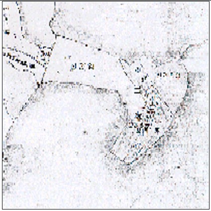
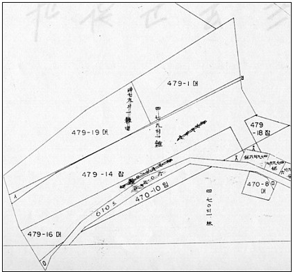
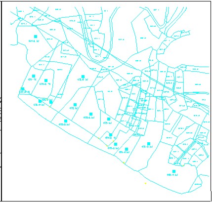
Fig. 1. Boundary on Cadastral Map
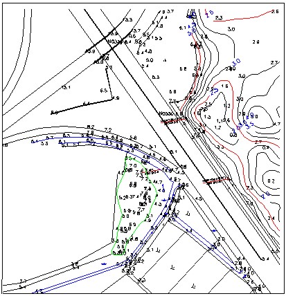
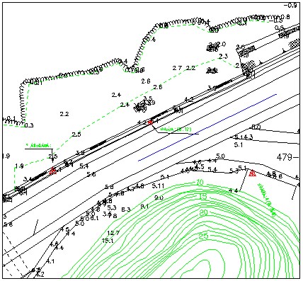
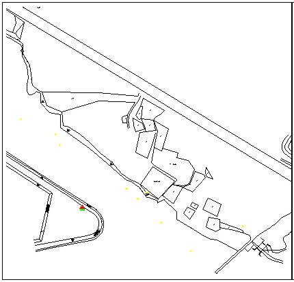
Fig. 2. Boundary on Map surveyed in site
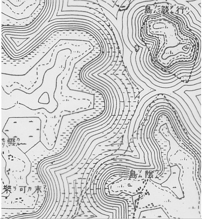
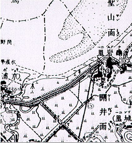
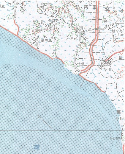
Fig. 3. Coastline of Secrete Military Map in 1906
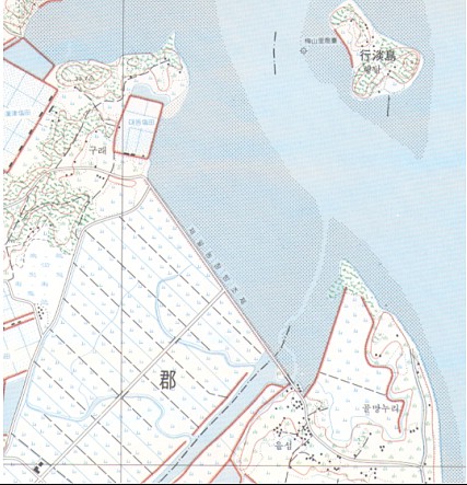
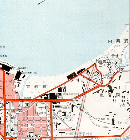
Fig. 4. Coastline of Base Map in 1974 3.2. Case II
Fig. 5. Boundary on Cadastral Map
Fig. 6. Boundary on Map surveyed in site
Fig. 7. Coastline of Base Map in 1918
Fig. 8. Coastline of Base Map in 1974 3.3 Case III
Fig. 9. Boundary on Cadastral Map
Fig. 10. Boundary on Map surveyed in site
Fig. 11. Coastline of Base Map in 1918
Fig. 12. Coastline of Base Map in 1974 4. DISCUSSIONWe could set up some hypotheses to discriminate between collapsed land after registration and a land registered wrongly. If the record in the cadastral book is improper, the disagreement of land boundary between cadastral map and the present state of the land may not mean the collapse of the land. If the cadastral map was made based on incorrect control networks, the boundary on a cadastral map may disagree with the boundary in site. If the boundary of topographic map made in the years when the land was registered is same to it of the map made in recent time, we could say the boundary of the land was not collapsed. As a result of cadastre investigation, no distinct errors were found in the records of cadastral book except the difference of area between cadastral book and cadastral map exceed the allowable area error (= ±0.02322MxF1/2)(MOGAHA, 1995). Because shrinkage or extension of map sheet cause some error of area calculation, it is reasonable to consider that the cadastre does not contain decisive errors. Because the site surrounding the investigated land have changed its category or its boundary, it was very hard to compare the boundary on cadastral map with that of surveyed in site for this study. Though the scale is not enough to investigate collapsed land, topographic maps made in different era gave the good evidence. When the maps made in different era were overlapped, the coastlines along land belong to Case I and Case II shows discrepancy in some extent. But the coastline along the land of Case II coincide between map made in 1900s and that made in 1974. Based on the comparison between maps made in different era, it is possible to say the lands belong to Case I and Case II was collapsed under the sea after registered. 5. CONCLUSIONAs a result of this study, we know that cadastral and topographic survey and its maps play an important role in proving lands to be collapsed or not. The map drawn on paper is subject to be shrunk or extended, it is highly recommended to digitalize cadastral map and topographic map. In addition to keep digitalized cadastre, it is desirable to archive aerial photographs or remote sensing images covering coastal areas periodically. REFERENCESKANG, In-Joon, CHANG, Yong-Ku, & PARK, Ki-Tae, 1994, Building of Land Ledge Database Using Land Information System, Journal of Korean Society of Geodesy, Photogrammetry, and Cartography, Vol. 12, No. 2, pp 141-146. NAM, Young-Woo, 1996, Japanese Military Surveys of Korean Peninsular in Meiji Era, New Directions in the study of Meiji Japan, Proceedings of the Meiji Studies Conference , E. O. Reischauer Institute of Japanese Studies. The KOREAN NATIONAL COMMITTEE FOR IUGG, 1987, Report of the Geodetic Works in Korea for the Period from Jan. 1910 to Dec. 1986 ( National Report to XIX General Assembly, Vancouver, Canada), pp. 1~2, Compiled by The IAG subcommittee. KIM, WonIk, 1994, Scheme of Digital Map Production for GIS in Korea, Surveying, Vol. 36, pp.12~21, Korean Association of Surveying and Mapping. LEE, JinHo, 1999, History of Cadastre in Korea, chap. 8~9, Barngil. MOGAHA, Korea, 1995, An Enforcement Ordinance of Cadastre Law, Paragraph 48. CONTACTProf. ChangKyung Lee 18 April 2001 This page is maintained by the FIG Office. Last revised on 15-03-16. |