ALKIS® - GERMANY'S WAY INTO A CADASTRE FOR THE 21ST CENTURYDr.-Ing. Winfried HAWERK, GermanyKey words: Integrated Cadastral Information System, ALKIS®, ISO standard UML, Cadastre 2014. AbstractGermany's tradition in cadastre is more than 150 years old. During the last three decades of the 20th century the analogue maps and records were digitised. Both digital cadastral maps and digital records are stored in separate systems. Since 1997 the Working Group of the Surveying Authorities of the States of the Federal Republic of Germany (AdV) has been developing a model of an integrated Official Cadastral Information System called ALKIS®. This system is the first one world-wide described by using ISO standard UML (Unified Modelling Language). The leading GIS companies will develop the software and distribute it to the authorities. The German surveying authorities plan to migrate their data and establish ALKIS® as soon as possible. The object structure will be the same as in the German topographical information system ATKISâ. So cadastral data can be easily used for topographical mapping and vice versa. ALKIS® represents a cadastral model on an international technical standard of high quality and will improve Germany's cadastre as a basic information system in the information society of the 21st century. In some but not all points it follows the state-ments of the FIG paper Cadastre 2014. This paper will describe the current status of Germany's cadastre, the reasons for the development of a new information system, the principle ideas of ALKIS® and how the migration towards this new model may take place. INTRODUCTIONThe Federal Republic of Germany established a high sophisticated cadastral system guaranteeing security of land tenure. With a long history of land registration in Germany it is a proven fact that a good working system of security of land tenure is very important for a developed society. Investments in land and buildings are very difficult or even impossible without a land registration system. Lessons learned during the re-unification process in Germany and the establishment of a market driven economy in the former socialist part of the country. The re-introduction of a cadastral system in the new states was a big task for the surveying professionals in the public and the private sector. The fastest and easiest way was to introduce the same systems that have been in operation in the western states of the republic since many years. These systems are the Automated Cadastral Map (ALK) and the Automated Property Register (ALB). The digital cadastral data base became a basic Land Information System for an increasing number of users in the public and private sector. The roots of ALB and ALK development date back to the 70s and 80s of the last century. Further development of these software systems seems not to offer future oriented solutions. Modern developments in object-oriented data bases, international standards and computer technology and the need to avoid inefficient work flows are the reasons for the German surveying authorities to follow a new and future oriented design of an Integrated Official Cadastral Information System ALKIS® in combination with a re-design of the Official Topographic and Cartographic Information System ATKIS®. DEVELOPMENT OF GERMAN CADASTRAL DATA BASESOrganisation of the Surveying Administration in Germany With respect to the federal constitution of Germany the responsibility for legislation in the field of cadastre is in the hand of the states. The 16 states have passed various, basically uniform, laws in the field of surveying. The different tasks are therefore not carried out by a central surveying authority responsible for the Federal Republic of Germany, but essentially by the Surveying and Mapping Administrations of the states. Tasks to be attended on a federal level are partly performed by the Federal Office for Cartography and Geodesy (BKG), an agency under the authority of the Federal Ministry of the Interior, but BKG is not responsible for cadastre. There is no federal institution responsible for cadastre supervising the authorities on a state level. The State Survey Offices and the responsible Ministries of the states co-operate through the 'Arbeitsgemeinschaft der Vermessungsverwaltungen der Länder der Bundesrepublik Deutschland' (AdV) (Working Committee of the Surveying Authorities of the States of the Federal Republic of Germany) to discuss technical matters of fundamental and national importance with a view to finding uniform regulations. Among others a main task of AdV is co-operation in the development and application of technical procedures, especially in the field of basic surveying, of the ATKIS® system, as well as the cadastral data bases. Therefore although cadastre in Germany is in the responsibility of the 16 states the cadastral data bases are highly uniform with only a few small but sometimes surprising exceptions. The Current Situation of Digital Cadastral Data Bases in GermanyThe Land registration system in Germany is a duplex system. The legal situation of each parcel is described in the land register called "Grundbuch". The geometric description of all boundaries in the Automated Cadastral Map (ALK), field records and textual records in the Automated Property Register (ALB) is in the hand of the cadastral authorities. Only Grundbuch and cadastre in combination are able to give a complete overview about legal and de facto land tenure. Both registers must be constantly updated and kept in correspondence with each other (DVW 1993). Beside its legal task of securing land tenure the cadastre became a basic Land Information System (LIS) of great variety and flexibility for planning, environmental protection and a lot more issues. The interface to the customers' data base is represented through the Unique Data Base Interface (EDBS) for ALK, if not DXF or TIFF format are required. Digital ALB data can be distributed by using an interface called WLDG which produces ASCII data. Both interfaces were developed by the surveying authorities, not following international standards (they did not exist in that time) but accepted by most users of cadastral records in Germany. Automated Property Register (ALB)The descriptive part of the real estate cadastre contains essentially data on
The structure and content of ALB has been harmonised at a nation-wide level. ALB has been in full operation in all states since many years. The eastern states of Germany have implemented ALB during the process of re-unification. ALB contains detailed information of approximately 61.3 million parcels in Germany. Automated Cadastral Map (ALK)The establishment of ALK has a history of more than ten years. The
basic concept of ALK dates back to 1975.
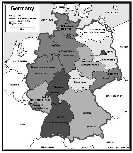
Following the principal theoretic guidelines of this concept the consequence would have been the re-surveying of many parcels to generate geometrically accurate data -a very long-term project. The pressure of user groups requiring a 100 % coverage of digital maps in a short period of time motivated most states to create a basic version of ALK by digitising the analogue cadastral maps. Especially in the eastern states this is a still ongoing process. In most urban areas ALK is in full operation. The status of ALK in Germany is shown in Picture 1.
Picture 1: Status of ALK in Germany (AdV, 1999) REASONS FOR RE-DESIGNA concept of an integrated cadastral data base was already designed 30 years ago but has never been carried out. The limited capacities of data processing equipment did not allow an integrated approach to this concept. Therefore ALB and ALK were developed as independent software solutions. Two independent data bases without mutual object structures cause some problems in maintenance, exchange and consistency of data. In consequence frequent inefficient checks are necessary in order to harmonise the redundant data in both data bases. In addition to these developments the Official Topographic and Cartographic Information System ATKIS® was established throughout the whole republic. ALK, ALB and ATKIS® do not have the same object structures which makes a straight data exchange almost impossible even if some features in ATKIS® could be derived out of ALK or ALB and vice versa. Despite these facts ALB, ALK and ATKIS® became the most important basic data for GIS in Germany used for a wide range of applications in the private and public sector. Increasing demands from the real estate market, banks, navigation companies etc. put a high pressure on the surveying authorities to establish a National Spatial Data Infrastructure based on these data. The approaches aiming at GIS interoperability like the ones which are coming up from the concepts of the international standardisation organisations CEN and ISO and especially from the Open GIS Consortium OGC play an important role for future decisions (AdV 1999). ALB, ALK and ATKIS® are not able to meet these modern technical requirements. When ALB and ALK were developed standards for data bases did not exist. Especially ALB was not designed for using a commercial relational data base management system. Considering these facts and trends AdV decided in 1995 not to invest in these software solutions in future, only to guarantee sustainability of the systems until 2005, but to invest in the development of a new integrated data base model for cadastre and topography, free of redundant data with a uniform object structure. GENERAL ASPECTS FOR A MODERN CADASTRAL DATA BASE IN GERMANYAdV decided that a further development of ATKIS® could only be seen in context with a re-design of the cadastral information systems. The result of a first rough analysis of the situation brought out that 75 % of all information to a parcel stored in ALK and ALB are redundant. An object oriented data base model of the entire cadastre seems to be meaningful and as a result of a market observation of current GIS software as well feasible. These were determining factors for AdV to establish a group of experts with the task to elaborate a concept for an integrated software solution for the cadastre in Germany. This system called ALKIS® in combination with the new ATKIS® is designed to
Of course links of the users' specific data they already linked to ALK, ALB or ATKIS® still have to be possible in the new systems without reasonable new investments on their side. They can trust in the sustainability of their investment in data. The object catalogues and data of ALKIS® and ATKIS® shall be harmonised in order to allow a vertical data flow avoiding data redundancy and double work in data acquisition and data processing. AdV followed the idea only to design and to describe the data base model. The GIS industry shall carry out the software solutions. The new ALKIS® standard therefore has to guarantee sustainability as well for the GIS industry in order to protect their long-term investment in the future ALKIS® software development. Essential for this approach is the use of a standardised data base description language with graphical and lexical features (AdV 1999). Of course one major claim is the option for a complete automated migration of the ALB, ALK and ATKIS® data into the new target systems. The access to ALKIS® data is restricted respecting the regulations of protection against the misuse of personal data. The access to ALKIS® for individual users are manifested in user profiles. ALKIS® produces access protocols to allow the observation of correct use by the data protection commissioners. PRINCIPLES OF THE ALKIS® MODELLINGBesides developing a conceptual data model it is essential for a comprehensive description of an application to develop a model of methods and a model of processes which allow to set the data in a functional interdependence and define the dynamic behaviour of the application. A suitable way to describe data and methods in an application is object oriented modelling. Methods in object oriented models are a part of objects and data are parameters of methods. In ALKIS® as an integrated data model for maps and descriptive data principles have to be defined and documented for geometric specifications between spatial contents under each other, general specifications between non spatial contents under each other and between spatial and non spatial contents. A major term of the data model is the object in form of spatial or non-spatial elementary objects. They are the smallest units in this data model and are defined through constant attributes and relations. The geometry (e.g. parcels, buildings) is defined only by the spatial elementary objects with topological (nodes, edges, faces) and geometrical (points, curves, surfaces) primitives. The non-spatial elementary objects (e.g. land owners) have no geometrical or topological features but can be administrated together with the spatial elementary objects and are linked to them by relations. Combined objects (e.g. survey control points) can be modelled by a combination of any spatial and non-spatial elementary objects. These objects can be established on different hierarchical levels. They don't have a geometry or topology but contain at least one elementary object. Initially ALKIS® was modelled by using the draft documents of the data base description language EXPRESS (EXPRESS-L for the lexical and EXPRESS-G for the graphical part) developed by the European Standards Body CEN. New developments on the fields of international standards forced AdV to reshape the description on the ISO standard Unified Modelling Language (UML) and for the definition of the data interface Extensible Markup Language (XML) documented in ISO standards 15046. The development of these standards reached a level where fundamental changes are not expected. DATA AND PROCESSES
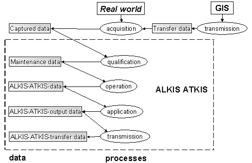
Picture 2: ALKIS®-ATKIS® data and processes The tasks of the surveying authorities are data acquisition, qualification, operation (setting up and maintenance of data), application and data transfer. Each of these tasks may be defined as a process. Relations between data and processes in AdV-terminology are shown in Picture 2. By definition through AdV the data acquisition process and the captured data itself shall not be modelled by ALKIS® because these processes are and will be designed individually by each state depending on different methods of data acquisition or different data sources. Data Acquisition ProcessThe sources for the data acquisition can be found in the real world with its objects and natural manifestations. The methods for data acquisition are the well known survey methods as well as data capture by digitising or import from other GIS. The target data of this process are the captured data which are basic for the maintenance of the official data bases. Qualification ProcessIn this process the captured data are transformed into maintenance data. This process of quality assurance guarantees that the data are in accordance to the required quality conditions of ALKIS®. The data are tested for actuality, consistency and plausibility. After having passed this tests successfully the data are used directly to maintain the cadastre. Operation ProcessThis process combines the activities for implementation and maintenance of ALKIS®. The implementation is seen as a special case of data maintenance. In this process the data (the data as such and the meta information) that were produced in the qualification process are transformed into ALKIS® and ATKIS® data by the methods deleting, registering, changing or changing their spatial reference. Application ProcessThis process transforms ALKIS® or ATKIS® data into output data due to the given standards as
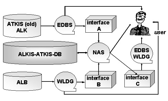
Transfer ProcessIn this process data from other GIS shall be imported in ALKIS® or ALKIS®-ATKIS® data shall be distributed to customers. This process supplements the output data with transfer functions to produce transfer data for the customers' GIS systems. Standard Data Interface NASThe development of a standard data interface operating with most GIS software is an important factor for data distribution. The currently existing interfaces EDBS for ALK and WLDG for ALB can only be used for a limited time in future. They need to be re-designed. The new NAS interface will be developed by using ISO standards 15046 for XML (Geographic information). MIGRATION CONCEPTSThe migration from the old systems ALB and ALK into the new systems ALKIS® and ATKIS® is only feasible by automated processing using the NAS interface. The advantages of the new system can only be achieved when the migration process is success-fully and completely finished. The migration generates investments on the customers' side in new software as well as in the migration process itself. This will be appreciated individually by each customer only in a balanced cost and benefit situation. Until that point is reached the users will require to be supplied with data they are able to process with their current software which means data transferred via the old data interfaces EDBS and WLDG. This requires the following steps (Picture 3):
Picture 3: data supply for customers in different stages
General requirements for the migration process are
A key role in the preparation for the migration process play the object catalogues containing all objects, attributes and relations showing which elements of the previous systems can be assigned to the ALKIS® elements. The migration process is a complex project but has to be finished in a very short time. The process is separated in four stages:
STATE AND FUTURE DEVELOPMENT OF THE PROJECTAdV's activities in modelling ALKIS® and ATKIS®, the definition of standard output products based on a XML interface and the meta data catalogue based on UML are completed. The NAS interface will be derived automatically from the UML model. This means that most AdV activities concerning the process of modelling ALKIS® and ATKIS® are completed. The member states in AdV agreed upon the basic contents of ALKIS® and guarantee a unique standard for the system and data in ALKIS® for the entire country. ISO established a test bed for ALKIS® to test the standards for feasibility. An AdV task force of representatives in co-operation with the Ministries of Justice developed a data interface for the data exchange between ALKIS® and the Grundbuch systems. Some GIS companies introduced already ALKIS® prototypes during the INTERGEO® 2000 Exhibition in Berlin. Most of these prototypes have been developed with OGC simple features under Oracle 8i spatial. The migration process has been tested with real ALB and ALK data. The results shown there confirm that ALKIS® seems to be an excellent cadastral model for at least the next decade. Some states in Germany are already on the track to establish ALKIS®, most states are planning and preparing the migration process. All states committed themselves to start with the implementation of ALKIS® not later than 2005. Both the public sector and the GIS companies have successfully designed and developed a future oriented cadastral information system. Most statements of FIG Commission 7 paper Cadastre 2014 are no longer science fiction in Germany. REFERENCESDeutscher Verein für Vermessungswesen (DVW): 1993, Organisation of Surveying and Mapping in the Federal Republic of Germany, Schriftenreihe 10/1993, Verlag Konrad Wittwer GmbH Stuttgart, ISSN 0940-4260 Arbeitsgemeinschaft der Vermessungsverwaltungen der Länder der Bundesrepublik Deutschland (AdV): 1999, Übersicht zur Verfügbarkeit geotopographischer Daten und digitaler Daten der Liegenschaftskarten, Landesvermessungsamt Baden-Württemberg Arbeitsgemeinschaft der Vermessungsverwaltungen der Länder der Bundesrepu-blik Deutschland (AdV): 1999, Amtliches Liegenschaftskataster-Informationssystem (ALKIS®) Teil I: Zielsetzung des AdV-Konzeptes, Version 07.0 Arbeitsgemeinschaft der Vermessungsverwaltungen der Länder der Bundesrepublik Deutschland (AdV): 1999, Amtliches Liegenschaftskataster-Informationssystem (ALKIS®) Teil II: Grundsätze der ALKIS®-Modellierung, Version 07.0 Arbeitsgemeinschaft der Vermessungsverwaltungen der Länder der Bundesrepublik Deutschland (AdV): 1999, Fortschreibung des AdV-Konzepts für die Modellierung der Geoinformationen des amtlichen Vermessungswesens Arbeitsgemeinschaft der Vermessungsverwaltungen der Länder der Bundesrepublik Deutschland (AdV): 1999, Modellierung der Geoinformationen des amtlichen Vermessungswesens, Grobkonzept einer möglichen Realisierung einer XML - basierten Datenaustauschschnittstelle, Prüfung der Notwendigkeit eines Prototyping E. Jäger, A. Schleyer, R. Ueberholz: AdV-Konzept für die integrierte Modellierung von ALKIS® und ATKIS®, Zeitschrift für Vermessungswesen ZfV, Juni 1998, page 176 BIOGRAPHICAL NOTEDr. Winfried Hawerk has a Doctor's degree for Engineering Sciences from the University of Hanover, Germany. He is working in the Department for Geoinformation and Surveying and is responsible for cadastre and Land Information Systems in Hamburg. He has been the German delegate to FIG Commission 7 since 1993. CONTACTDr.-Ing. Winfried Hawerk 20 April 2001 This page is maintained by the FIG Office. Last revised on 15-03-16. |