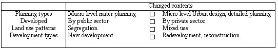
A STUDY ON THE DEVELOPMENT OF URBAN LAND INFORMATION SYSTEM FOR SUSTAINABLE URBAN MANAGEMENTProf., Ph.D. Junehwan KOH, KoreaKey words: GIS, Sustainable Urban Management, Land Use Information System, and Land Information System. AbstractThis study aims to develop the Extended Urban Land Information System (EULIS) which can support the sustainable urban management. The existing Urban Land Use Information system (ULUIS) that can supply the micro-level land use information will be good means for the understanding of urban spatial structure and district-level planning and management (such as urban design, redevelopment planning and district-level transportation planning, etc.). But, ULUIS has some constraints which can not supply the information for sustainable urban management, such as environmental and traffic analysis, urban infrastructure's carrying capacity analysis, etc. The EULIS will efficiently supply the information for sustainable urban management. For the successful construction of EULIS, the followings have to be considered. 1) the integration of topographic map which contains the building's footprints and cadastral maps which contain the parcel's boundary, 2) the integration of EULIS and FM (Facility Management) system for the full utilization of information about infrastructure's capacity analysis, 3) the construction of standardized georeferencing system and spatial unit for the combined use of environment and traffic census data. This study shows 1) why EULIS is needed for the sustainable urban management and which elements are needed for the system, 2) the E-R data model for the EULIS, 3) the strategies for the construction of EULIS and 4) conclusion. 1. INTRODUCTION1.1 The purpose of the studyIn Korea, the urban developments are implemented by the designation of zoning and districts according to the urban planning law for growth-oriented urban policies since 1960s. By the rapid urbanization, the shortage of housing was one of the most serious problems. But, by the increase of citizen's income level, they want to live in the better Quality of Life (QOL). So, the paradigms of urban policies are shifted to the growth management from development-driven policies. These kinds of policy will make possible to solve the problems that are caused by growth-oriented policies. Cities will be more sustainable. There are some limits to supply infrastructure continuously to the over-crowded city. In the transportation field, Traffic Demand Management (TDM) is introduced such as parking permit policy that restricts the build of parking space in the CBD area which has the mass transportation system such as subway. Environment management policies that try to reduce the production of garbage are introduced such as the separate garbage collection, the reuse of waste and the payment by solid-waste weight, etc. Kown (1998) asserts that the urban development has to be realized environmentally sound, sustainable and humanistic. The paradigm of urban planning and development will be change as shown <Table 1>. The type of the needed data by this change will be changed from the macro-level and area-wide regional data to the micro-level and detailed data.
Table 1. The shift of urban planning paradigm The chapter 7 of the Agenda 21 which is adopted at RIO environment and development conference in 1992 suggests the program for the promoting sustainable human settlement development as follows: (1) providing adequate shelter for all, (2) improving human settlement management, (3) promoting sustainable land-use planning and management, etc. To implement these programs, the following means are suggested: (1) improving urban management, (2) strengthening urban data systems, (3) undertaking a comprehensive national inventory of their land resources, (4) accessing to modern techniques of land-resource management, such as geographical information systems, satellite photography/imagery and other remote-sensing technologies. The above means have little attention to the inner area's sustainability and the relationship and the impact among the components (such as people, establishment, land use, etc). The purpose of this study is the development of Extended Urban Land Information System (EULIS) that can manage the highly developed inner urban area sustainable by extension of Urban Land Use Information System model (Koh, 1995). 1.2 The study methodThe area of this study is focussed on the highly, densely and vertically developed urban area. The data for this kind of study will come from:
Traditionally, the data for urban planning come from the land register's land category or the building register's major usage. This kind of urban land use data that can not show the land use characteristics of highly developed area, shows only the overall trend of land use. This will not be appropriate for the analysis of area whose land use is vertically differentiated. (Kim & Koh, 1995, p.184). This paper proposes the Extended Urban Land Information System (EULIS)
model that is possible to manage the city more sustainable. Also this
study suggests the method of integrating the data of the government's
computerization projects (such as digitalized land and building
register system, NGIS project for national base map construction,
etc). This Paper consists 2. SUSTAINABLE URBAN MANAGEMENT AND LAND INFORMATION SYSTEM (LIS)2.1. The concept of sustainable urban managementThe most widely cited definition is that of the World Commission on Environment and Development (WECD, 1987), also known as the Brundtland Commission:
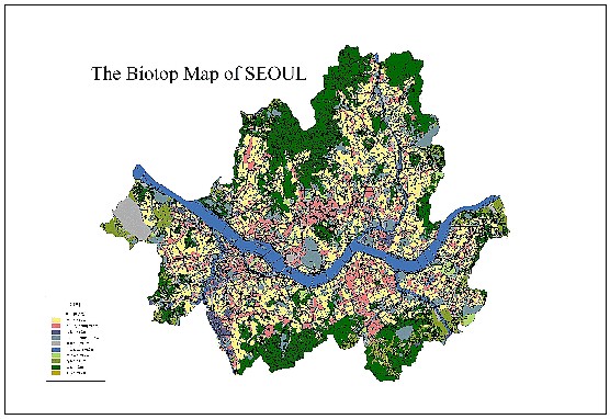
The Rio declaration on Environment and Development in 1992 proclaims the principles. Principle 3 that contains the concept of sustain development is "the right to development must be fulfilled so as to equitably meet developmental and environmental needs of present and future generations". The indicators for the measuring the achievement of sustainability in the United States, that is recommended by the president's Council on Sustainable Development, have to include the economic propensity, environmental health, social equity and welfare. Kim, et al. (1997) suggest the sustainable urban development strategies as follows: (1) to plan more park and green space in the city, (2) to improve pedestrian space and network, (3) to make a city culturally richer place, (4) to reduce the traffic demand, (5) to build the urban information system, etc. The land cover and Biotop survey using the GIS and remote sensing technique is conducted by Seoul Metropolitan Government (SMG) recently. The Biotop survey data will be very useful for the sustainable urban planning and management, urban ecosystem conservation and restoration, etc. SMG will periodically produce the Biotop map that shows the current ecological status of Seoul. Below figure is the Seoul's Biotop Map (from http://green.metro.seoul.kr/). These kinds of study and survey are using the more area-wide land use information. So, they are more appropriate for the macro-level and 2-dimensional analysis. But, the future city will be more compact, high-rise and will have higher density structure than now. Such city's sustainable development and management will be possible by the continuous monitoring of urban infrastructure's carrying capacity. By the construction of EULIS that contains parcel, building and user's traffic and environmental characteristics, the sustainable, micro-level, scientific and efficient urban management will be possible.
2.2. The construction of Land Information SystemAs introduced early, the construction of land inventory and LIS are recommended by the Agenda 21. To promote sustainable land-use planning and management, the following means are suggested:
According to the issues of the agenda of Habitat II conference that held in Istanbul in 1996, the necessity of construction of LIS for the more integrated and better land management is emphasized. And the existing urban infrastructure has to be fully utilized and the development has to maintain the proper density according to the carrying capacity of facilities. At the same time, the International Federation of Surveyors (FIG), particularly Commission 7 that is responsible for cadastre and land management published "Statement on the Cadastre" in 1994. Among the roles of cadastre, the sustainable development and environmental protection are stressed. "A Cadastre is normally a parcel based, and up-to-date land information system containing a record of interests in land (e.g. rights, restrictions and responsibilities). It usually includes a geometric description of land parcels linked to other records describing the nature of the interests, the ownership or control of those interests, and often the value of the parcel and its improvements. It may be established for fiscal purposes (e.g. valuation and equitable taxation), legal purposes (conveyancing), to assist in the management of land and land use (e.g. for planning and other administrative purposes), and enables sustainable development and environmental protection." The theme of the conference sponsored by ISSS and ITC is "Geoinformation for Sustainable Land Management". The concept of Sustainable Land Management (SLM), the construction of Geo-Information Infrastructure (GII) for SLM, etc. were dealt. In Korea, the government and the research institutes have been attended the development of Land Information System development since mid 1980s. As one of the administrative information system of government, the land register was computerized in the late 1980s. Korea Research Institute for Human Settlements (KRIHS, 1985) had a research about the Urban Information Management System. The researches and developments on Land-related information system as the National Information Infrastructure (NII) have been accomplished such as follows: (1) Ministry of Home Affairs (MOHA, 1993) and Korea Computerization Agency's research on the development of Parcel-based Land Information System (PBLIS), (2) Ministry of Construction and Transportation (MOCT, 1995)'s National Geographic Information System (NGIS) project, (3) Seoul Development Institute (SDI, 1996)'s research on the development of Land Use Information System (LUIS) for Seoul, etc. 3. THE ANALYSIS OF THE EXISTING URBAN LAND USE INFORMATION SYSTEM (ULUIS) MODEL3.1 The characteristics of urban land useThe users, such as people and establishments, bring on the urban land use. The land use gives rise to the urban infrastructure's foundation. The land use that is represented by the urban activity has the close relationship with the infrastructure. The appropriate combination between the activity and the infrastructure will make the city more pleasant and safer to the peoples. The types of the activity in the future will be more diversified than before. It will gradually arouse the mixed land use patterns. By the Procos (1976), the multi-purpose and mixed use of parcels and buildings considered as not changing within a certain period of time. That is, the industrial area that is developing to the residential use is considered as industrial use. But, the purpose of large-scale comprehensive developments is the round-the-clock use of the buildings. So, in the measuring the changes of land use, the time variable has to be considered. 3.2 The analysis of Existing ULUIS ModelThe study on the development of Urban Land Use Information System (ULUIS) Model (Koh, 1995) is focused on the urban land use, especially detailed and vertically differentiated land use. The vertical expansion of great cities makes impossible to understand the land use pattern with the aerial photograph and remote sensing data only. 3.2.1 The data collection system The data collection system of the ULUIS Model is as follows: (1) the digitizing of the building's footprints from the aerial map (1:1,200 scale) and the parcel boundary from cadastral map, (2) the input of attribute data, such as address, area, land value and owner from land register, use, year of built, number of stairs from building register, classification by industry, total floor area and number of employees from establishment register, (3) the field survey for parking lot, open space, etc. The digitalized attribute data has to be opened to the public and fully utilized for the maintenance of ULUIS database. It will reduce to cost for the construction of the database. 3.2.2 The entities of ULUIS database The ULUIS Model is based on the relational database. After the conceptual model is built, the E-R model is fully normalized for the perfect retrieval and the no duplication. The entities of this model are parcel, building and establishment. 3.2.3 The usefulness and limits of ULUIS model The usefulness of Urban Land Use Information System is as follows:
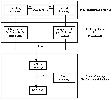
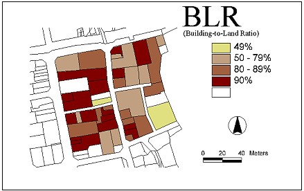
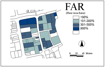
The FAR which implies the density of urban development can be calculated and shown with this system. <Fig. 1> is the flowchart for BLR and FAR. <Fig. 2> and <Fig. 2> are the result maps of BLR and FAR each. Those information can be utilized in the designation of redevelopment area and detailed area planning (such as Germany's B-planning).
Fig. 1 The Flowchart for BLR and FAR
Fig. 2. The BLR Map
Fig. 3. The FAR Map This kind of Urban Land Use Information System model that is using the SIC (Standard Industrial Classification) code of establishment can provide more accurate and scientific land use information than the existing land use information acquisition system using land register's land type or building register's building usage type data. This model is more useful than traditional methods in the understanding of land use patterns for densely developed urban area such as CBD. But, It has some limits such as follows:
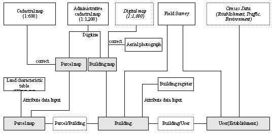
By these limitations, Extended Land Information System model is proposed for the sustainable urban management. 4. THE CONSTRUCTION OF THE EXTENDED URBAN LAND INFORMATION SYSTEM (EULIS) FOR SUSTAINABLE URBAN MANAGEMENT4.1 The necessity of EULIS modelThe necessity of EULIS development is to make possible the sustainable urban management. The basic analysis of vertically differentiated land use is possible by the existing ULUIS. But, for the more detailed and sustainable analysis to the urban land, the ULUIS has to extend the entities and fields such as environment, traffic and infrastructure-related items, etc. In order to possible to manage the city sustainable, more efficient land information system has to be built. And the sustainable urban management is conducted within the carrying capacity of infrastructures and urban eco-system. Namely, the urban land use, energy consumption, traffic generation and waste disposal has to balance between the urban eco-system and built environment system. 4.2 The construction of EULIS Model4.2.1 The data collection system EULIS's data collection system is based on the existing land use information system. <Fig. 4> shows the inclusion of the environment and traffic census data for sustainable urban management. Digital map that is made by Korean government's National Geographic Information System (NGIS) project is used as base map. The Ministry of Government Administration and Home Affairs (MOGAHA)'s Parcel-Based Land Information System (PBLIS) is the base of the EULIS. The comprehensive urban land use census that shows the environmental and traffic condition, etc. has to be conducted periodically. The spatial unit of these data is based on the user of building. Fig. 4. EULIS's Data Flowchart
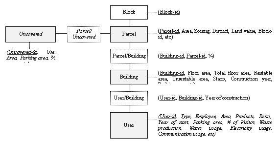
4.2.2 The entities of EULIS EULIS is based on the relational database concept same as existing ULUIS. The EULIS's E-R model that has added some fields for sustainable urban management is possible is built as <Fig. 5>. The added fields, that can be used as basic data for urban infrastructure's planning and capacity analysis, are the solid waste production by type, the number of visitors, the parking area, the water and electricity use, etc. Fig. 5. EULIS's E-R data model
4.2.3 The strategies for EULIS construction and application The success and usefulness of EULIS depends on the fact that is how much well applied to the sustainable urban planning and management. The application system that can provide the indicators and can monitor sustainability has to be developed. And for the full operation of EULIS, the followings have to be considered. Firstly, the topography map that contains the building's footprint and the cadastral map have to be merged one digital map. Secondly, the comprehensive survey and census have to be conducted for the integration of land use data, the transportation and environmental data that can be the attribute data of EULIS. Thirdly, EULIS has to be integrated with the facility management system to provide information for deciding the size and location of urban infrastructure. Finally, the Biotop map data also has to be integrated to the EULIS system. 5. CONCLUSIONIn this paper, the model of Extended Urban Land Information System (EULIS) which is possible to sustainable urban management is suggested. Existing Parcel-based Urban Land Use Information System (ULUIS)'s usefulness is also proved. ULUIS is essential to the analysis of current land use and urban spatial structure, and the more detailed urban planning and developments. But, it is impossible to provide the information for the sustainable urban management. By the need assessment for EULIS, some items are added onto the ULUIS, and E-R model is built. Also, the development strategies for more efficient system are suggested. The further researches for the more efficient EULIS system development have to be conducted as follows; (1) the more precise and detailed demand analysis of sustainability, (2) the implementation of land use census and the development of the field survey methodology, (3) the development of the land use classification system such as USA's Land-Based Classification Standards(APA, LBCS), (4) the improvement of the institutions about the data sharing and the protection of privacy. REFERENCES
CONTACTProf. Junehwan Koh 22 April 2001 This page is maintained by the FIG Office. Last revised on 15-03-16. |