In this presentation, following mainly the U.N. Ad Hoc group of Experts on Cadastral Surveying and Land Information (1985), land is defined as an area of the surface of the earth together with the water, soil, rocks, minerals and hydrocarbons beneath or upon it and the air above it. It embraces all things which are related to a fixed area or point of the surface of the each, including the areas covered by water, including the sea.
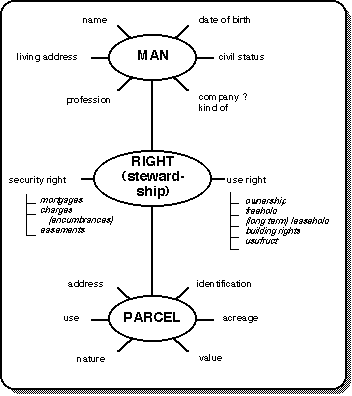
Land in relation to land registration and cadastre and in general to land information systems to which category land registration and cadastre belong, concerns not only abstract or thematic attributes (legal status, value, tax data) but also physical, spatial or topographic ones (location, dimensions, area, use).
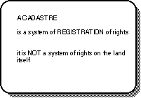
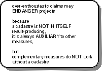
Because land registration and cadastre (who and how along with where and how much) complement each other, the terms "land recording" or "land records" are usually used to indicate that these two components belong together as a whole.
Every well organized form of a human society will define rights on the land. There are strong ties with the fundament of the social and political structures and the religious beliefs. Being able or not to exercise rights on the land can create deep emotions and often plays a vital role in the individual's feeling concerning the possibilities of participation in society. Besides, it is a strong factor in the considerations to invest labor and/or capital in the land.
There exits a great range of forms of land tenure as there are:
* the Anglo-American concept (in theory feudal);
* the Roman-French-German concept (allodial system);
* the Communist concept (state, cooperatives);
* the Islamic concept (religion);
* the Customary concept (community).
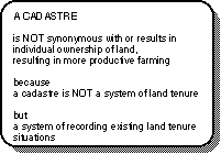
In many developing countries there is a tendency to convert communal customary land tenure to individual tenure, that is expected to increase economic productivity in various fields.
In East-Europe the recent tendency to move from a planned economy towards a market economy includes a change from communal to individual stewardship of land. The fundamental changes in land laws (land tenure) that have been put in place have to be complemented by registering land ownership rights and transactions and by issuing land titles. This may change the role and character of existing land administration from economy- or ecology-oriented systems into legally oriented ones for the legal protection of individual land tenure, of course still serving economic and ecological purposes.
a) The booking principle implies that a change in real rights on an immovable property, especially by transfer, is not legally effectuated until the change or the expected right is booked or registered in the land register.
b) The consent principle implies that the real entitled person who is booked as such in the register must give his consent for a change of the inscription in the land register .
c) The principle of publicity implies that the legal registers are open for public inspection, and also that the published facts can be upheld as being more or less correct by third parties in good faith, so that they can be protected by law.
Concerning the public inspection, it can be remarked that in various countries the land register is open for inspection whether by anybody who wishes to do so (The Netherlands, Belgium, France), or by anybody who has a legally recognized interest in what is published (Germany), or by the registered owner or anybody who has a permission of the registered owner (in England, until 1991). In the last case the privacy element is very dominant.
There is a need to open the registers, which were up to now more or less "closed" for inspection by anybody. The register thus can not only assist in the simplification of conveyancing but will also help in identifying the ownership of properties for other purposes, such as conservation and development. Therefore the land register will be an important component of a concept of a broad land information system. Evidence of this need can be found in England, where the Land Registration Act of 1988 heralds the end of the privacy of the register. This Act was brought into force in 1991.
d) The principle of specialty implies that in land registration, and consequently in the documents submitted for registration, the concerned subject (man) and object (i.e. real property) must be unambiguously identified.
Depending on the nature and extend of involvement of the state in the conveyancing process, which appears in activity or passivity of the state and which has the root in the "legal" history (in Continental Europe Roman law and Germanic law), there exist two recognized systems of land registration, the deed and the title registration system.
A deed registration system means that the deed itself, being a document which describes an isolated transaction, is registered. This deed is evidence that a particular transaction took place, but it is in principle not in itself proof of the legal rights of the involved parties and, consequently, it is not evidence of its legality. Thus before any dealing can be safely effectuated, the ostensible owner must trace his ownership back to a good root of title.
Deed registration, whether the "basic" or the "improved" one (=based on a survey and on documents of competent notaries as well as on an active role of the register) is usually applied in countries which are mainly based on the Roman law (in Europe: France, Spain, Italy, Belgium, The Netherlands) and also in countries that were influenced by the former ones in earlier times (South-America, parts of North-America, some African and Asian countries).
A title registration system means that not the deed, describing e.g. the transfer of rights is registered but the legal consequence of that transaction i.e. the right itself (=title). So the right itself together with the name of the rightful claimant and the object of that right with its restrictions and charges are registered. With this registration the title or right is created.
So one could say that deed registration is concerned with the registration of the legal fact itself and title registration with the legal consequence of that fact. In other words, the relation between deed and title registration is similar to the relation between legal facts and legal consequences.
Concerning the effect of a land registration system, especially a title registration, three principles are sometimes upheld namely the mirror principle, which means that the register is supposed to reflect the correct legal situation; the curtain principle, which means that no further (historical) investigation beyond the register is necessary except overriding interests; and the insurance or guarantee principle, which means that the state guarantees that what is registered is true for third parties in good faith and that a bona fide rightful claimant who is contradicted by the register is reimbursed from an insurance fund of the state.
Around the world, there are different categories of title registration systems, which do have the same principles but differ mainly in procedures:
* the English Group: a.o. England, Ireland, some Canadian provinces, Nigeria.
* the German/Swiss Group: a.o. Germany, Austria, Alsace-Lorraine, Switzerland, Egypt, Turkey, Sweden, Denmark.
* the Torrens Group: a.o. Australia, New Zealand, some provinces of Canada, some parts of the USA, Morocco, Tunisia, Syria.
This classification is rather arbitrary, but it is largely geographical and tends to reflect differences in land law rather than differences in registration principles.
The cartographic/mapping/surveying aspect differs between the 3 groups i.e. the English group makes use of large scale ordnance survey maps, the German group of parcel-based cadastral maps, and the Torrens group makes use in principle of incidental survey plans.
A better attempt to categorize title registration systems on more realistic points would be:
* whether or not registration carries a state guarantee;
* whether rectification of the registration on ground of error, fraud or adverse possession is allowable;
* on differences in maps and survey and in the methods of initial compilation.
Regarding the Torrens system, it can be remarked that Sir Robert Richard Torrens introduced it in 1858 in South Australia. Under his name, this system was spread throughout Australia and to some other parts of the world. Robert Torrens appears to be influenced by the German land registration in Hamburg and by the German shipping registration. Referring to the book "Transfer of Land in Victoria" by S. Robinson 1979, he chartered Dr. Hübbe from Hamburg to assist in developing the Torrens system in South Australia.
Sometimes a deed registration system is indicated as to be synonymous with a negative or a passive system and a title registration system with a positive or active system. Usually in a deed registration system recording does not automatically guarantee the concerned right. Such a system is negative and as a consequence passive in analyzing the documents. A title registration, as we have seen, guarantees the title, gives positive legal force, and as a consequence the state has to be active in analyzing the documents in order to avoid damages and compensations. The more guarantee by the state there is, the more investigation has to be done by the state, or, in other words: the more positive a system is, the more state activity is required.
Besides the map or the geometrical part there exists also a descriptive or alphanumeric part of the cadastre: a register which contains physical attributes of the parcel i.e. identifier, local location, area, kind of use and abstract attributes like data for land tax such as value, proprietor and/or taxpayer. Usually there exists also a reference to the land register. One can say that the task of a cadastre is mainly geometrically oriented i.e. fixing and representing the parcel.
As the heart of a cadastre is the parcel, it is necessary in this context to pay attention to some relevant aspects:
a) Generally - whether for legal use or for ecological applications - a land parcel can be defined as a continuous area of land within which unique and homogeneous interests are recognized.
On behalf of legal cadastral purposes such a parcel reflects a homogeneity in legal interest and on behalf of land use purposes such a parcel reflects a homogeneity in use.
Usually these parcels are surveyed and mapped by a closed line and indicated by a number (parcel identifier) on the map.
b) In relation to the parcel boundaries the question on what data can be relied on plays a role. The English system relies mainly on physical boundary features, man-made or natural. The precise position of the boundary within these physical features depends on the "general" land law of the country concerned. This boundary system is known as a "general boundary system". The system provides, however, for the precise surveyed boundaries to be "fixed" if desired by the owners. After entering the precise survey data in the land register the boundary is "legally" fixed for everybody and guaranteed. Without registering the precise survey data, these boundaries are not legally fixed and have the legal effect of "general boundaries". The term "general boundaries" originates from the English land recording system.
The choice between "general" and "fixed" boundaries depends on the pace of creating or updating the system, the existence of physical features, disputes to be expected, the amount of necessary security and the costs. A cost/benefit analysis is of course necessary.
c) Concerning the identification of the parcel is remarked that this has to be simple and easy to understand, unambiguous, reliable and flexible (compatible with various parcel oriented information systems). There is a tendency towards using also identification by coordinates. This is done on behalf of coupling with other systems and of cartographic representation of various land recording data.
Land registration and cadastre are like a three-legged stool. One leg represents legal data, one physical or thematic data, and one surveying data. This implies a cooperation between notary, registrar, and surveyor in order to obtain authoritativeness, completeness, and (legal) validity of the system.
Within the above mentioned cooperation the division of responsibilities should be as follows:
* the notary is responsible for the correctness of the documents to be presented to the registrar;
* the surveyor is responsible for a correct and workable identification of the real properties being object of the right;
* the registrar is responsible for the land records, more precisely for their aim to contribute to a correct picture of the (legal) situation of the real properties;
* the information technology manager covering all modern advanced technologies necessary for recording and supplying information.
If this cooperation works, the land recording system will function satisfactorily, even if there is a weak legal base.
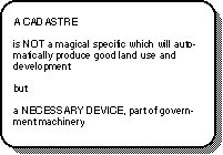
Because citizens are involved with land registration or the cadastre, their confidence in the system must be assured. The public must be informed of the purpose of the system and must understand how and why it works. Failure to do so will lead to subsequent dealings in land going unrecorded and this will sooner or later lead to legal and other difficulties. To be successful, a land registration and cadastre must enjoy Popular support.
Speaker: Prof.mr.ir. J.L.G. Henssen Tel. +31-43-257 364
Patersbaan
10A
NL-6211 KZ Maastricht
THE NETHERLANDS
Remark: Parts of this text are extracts from the Lecture "Cadastre and its legal aspects" from Jo Henssen in the Lecture Material, Workshop E, "From Research to Application through Cooperation" of the Joint European Conference and Exhibition on Geographical Information in The Hague, The Netherlands, March 26-31, 1995.