The aim of my presentation today is to:
* highlight the multipurpose character of the Swedish cadastral system,
* highlight the strengths and weaknesses of the system and to give indicatives about tendencies and problems of innovative projects.
The Background and History of the Swedish Cadastral System
The Swedish cadastral system has a long history. During the 15th and 16th century Sweden became a centralized state with a powerful monarchy, who needed land information for tax purposes. The first registers were made in the 16th century and land has been registered since this time. Registration quickly became a part of the procedures tied to purchases and mortgaging. The National Land Survey was established at this time (1628).Parceling reforms and the aristocracy's loss of privileges were important steps in the 18th century. The Swedish system for land registration, which has been complete since the beginning of the 20th century, is quite simple and straight forward. In essence it is very similar to the Torrens system.
Computerized registration had been studied already in the late sixties. The computerization of the Property Register and the Land Register did however start around 1970. After pilot projects, the gradual implementation of the so called LDBS began in 1976 and will be finished this year.
The history of the registry map is almost as long as the register.
The Content of the Cadastre System
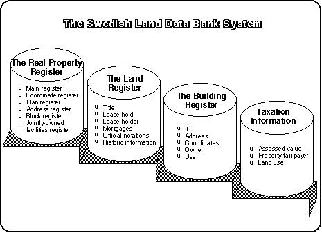
All properties in Sweden are registered.The Swedish Cadastre system contents a Property Register and a Land Register.
The handling of the Property Register and Land Register has been automated into one EDP-system. The EDP-system has replaced the old books which previously was in use. This non-graphic system is called the Land Data Bank System.
The Property Register is the basic administrative register for real properties in Sweden. The register includes a property index map. This map is kept separately from the textual register.
The property index map for rural areas is based on the land-use map. This is printed in a scale of 1:20 000, but is maintained on originals in a scale of 1:10 000 at the regional authorities. The map is based on a orthophoto plan. Reporting is done using a coordinate system common to the whole country.
Today 2/3 of the Land Use Map and Registry Map are digitized. The graphical information is stored in different layers for different type of information.
The property index map for urban areas are based on large-scale municipal base maps, with either the national grid or local reference system. These cadastral index maps are produced to a scale of either 1:1 000 or 1:2 000. More than half of this information is converted into digital form.
The documents, maps and marks on the ground produced in the property formation process form the legal basis for the division of land into real properties and we have the same legislation for the cadastral process and cadastre in both the urban and rural areas.
The contents in the Property Register and Land Register are mainly based upon documents and records kept at the Property and Land Register Authorities.
The Property Register contains records of the
- area of real properties, and
- the property designation.
The register also contains further information on easements, land-control and zoning regulations, archive references, the centroid coordinates for each parcel of the property, and the street address of the properties.
The Land Register contains information about the
- legal owners name,
- address, and
- civil registration number.
It also contains information about mortgages, encumbrances, and notifications from other authorities on things such as bankruptcy, restoration orders etc.
The Land Data Bank System also contains information from the Real Property Assessment Register and the Population Register.
The Register of Buildings consists of an
- identity (connected to the property identifier) for each building used for residential, commercial or industrial purposes, linked to data on
- the situation of the building,
- the use of the building, and
- the value of the building.
The register will be kept up-to-date through connections with the Property Assessment Register and the building permit process in the municipalities.
The Purpose of the Cadastre
The most fundamental purpose of property and land registration in Sweden is:- to establish certainty of ownership and rights to land,
- to give publicity and legal protection for land tenure,
- to facilitate the transfer of land, and
- to provide easy access to information about land.
The register also serves important activities in society such as:
- property taxation,
- agricultural statistics,
- land surveying,
- environmental monitoring,
- urban and regional planning,
- population registration, and
- financial sector.
The content of the Land Register has legal power and is guaranteed by the Government, with provisions for compensation in case of losses suffered under certain conditions.
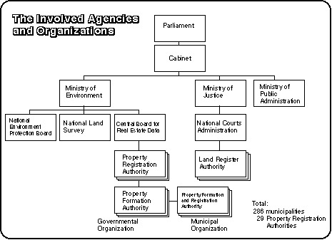
The Organization
In Sweden, as in most other countries, the responsibility for property formation and registration (the division of land into real property units) and land registration (ownership and encumbrances) lies with different organizations.Property formation is carried out by the Property Formation Authorities. The Property Register is the responsibility of the Property Register Authorities. There are 53 such authorities. The National Land Survey of Sweden (NLS) has a supervisory responsibility for real property formation and registration.
The Land Register is maintained by 93 Land Register Authorities. These authorities are part of the District Courts and are administratively supervised by the National Courts Administration.
The Central Board for Real Estate Data (CFD) has the main responsibility for
- development,
- implementation and
- technical operation of the Land Data Bank System (LDBS) and -distribution of information from the system. The property and land registers are maintained in the LDBS. CFD works in close cooperation with the land survey and the court organizations.
These agencies and authorities, except some of the Property Register Authorities (which are municipal), are all governmental organizations.
The National Courts Administration and the court organization is under the Ministry of Justice. NLS and CFD are under the Ministry of Environment and Natural Resources.
Financing
The property formation procedure is financed directly by fees from the applicant. The work carried out by the Property Register and Land Register Authorities is funded by fees paid for applications at the Land Register Authorities, while the operations of CFD are funded from the same fees and fees paid directly to CFD for information and other services from the LDBS.
The Users of the System
The LDBS provides for the constitutional openness and public access. It also has to provide for other needs for land information in society.The basic access to information is available at all public agencies connected to the system. Information can be obtained free of charge on telephone or on visits. Print-out copies can also be obtained at cost price. More than 20 000 terminals are connected to the LDBS. We find the users in land surveyor offices, local government, banks, insurance companies, real estate agents and the like which have access to the system for information retrieval purposes.
The system provides:
- Official documents produced from the system like title deeds and certificates.
- As for extracts and compilations there are several products available.
- Lists of properties can be produced which include selected pieces of information concerning the properties, in general the owners.
- Through LDBS connection to the population register, population-maps can be produced.
- Output can be delivered on different media.
- Procedures have been developed to meet the clients different and specific requests for selection and delimitation of information.
- The coordinates in the LDBS play an important role in this work.
The Strength`s of the System
There are many benefits of the cadastral system. The system is:- in function,
- covers the whole country,
- certifies the ownership, and
- the rights to land.
The system facilitates:
- the transfer of land and
- other land related activities.
The registers serve important purposes as far
- as real estate credit,
- taxation, statistics,
- planning and population registration.
The basic objectives behind the establishment of the LDBS were to improve the operations of the register authorities and to facilitate access to land information in society. The objectives have been achieved. There has been considerable reduction in turn around times for applications lodged with the register authorities and there is a continuously growing demand for and utilization from the LDBS in society.
The costs for development, implementation and operation of the LDBS is covered by fees charged to those who initiate changes of the registers (e.g. applicants for title and mortgages) or request official documents. Depending on the activity on the property market the total amount collected varies between four and six billion SEK (billion = miljarder). Properties are subject to a property tax. The tax is paid by the property owner and collection is made as part of the income taxation.
Other strengths of the system are
- the availability of the system of 99 %,
- the safety system is very secure,
- the system is easy to reach, and
- the answers are given very quickly.
The conclusion is that we have a well functioning system, with a good economy which serves its purpose.
Speaker: Agneta Ericsson Tel. +46 26 15 33 83
Project Manager Fax +46 26 65
18 19
SWEDSURVEY
S - 801 82 Gävle
SWEDEN
Maintainer : David Mercer - webmaster@fig07.force9.co.uk Last Modified: September 1996.